Calovébora geodata
Calovébora (Veraguas) is a seat of a third-order administrative division; located in Panama in America/Panama (GMT-5) time zone. With population of 117 people, there are 648 cities with bigger population in this country. Compared to other cities in Panama, 73% of cities are located further ↓South; 65.2% of cities are located further →East and 80.4% of cities have higher elevation than Calovébora. Note1


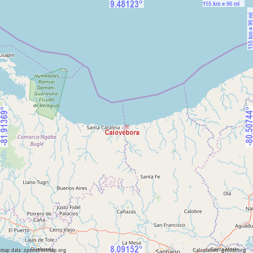
Calovébora GPS coordinates[2]
8° 47' 13.308" North, 81° 12' 38.016" West
| Map corner | latitude | longitude |
|---|---|---|
| Upper-left | 9.48123°, | -81.91369° |
| Center: | 8.78703°, | -81.21056° |
| Lower-right: | 8.09152°, | -80.50744° |
| Map W x H: | 154.5×154.5 km | = 96×96mi |
| max Lat: | 9.60898° ⇑27% North |
| Calovébora: | 8.78703° |
| min Lat: | ⇓73% South 7.26534° |
| min Long | Calovébora | max Long |
| -82.91275° | -81.21056° | -77.38965° |
| W 34.8%⇐ | ⇒65.2% E |
Elevation
Elevation of Calovébora is 23 m = 75 ft, and this is 149.1 m = 489 ft below average elevation for this country.
| Max E: |
2103 m = 6900 ft | 80.4% |
| Avg. | 172.1 m = 565 ft | |
| Calovébora | 23 m = 75 ft | |
Min E: |
-1 m = -3 ft | 19.6% |
See also: Panama elevation on elevation.city.
Geographical zone
Calovébora is located in North Torrid zone (between Equator and Tropic of Cancer). Distance of Equator is 977 km =607.1 mi to South.| Distance of | km | miles | from Calovébora |
|---|---|---|---|
| North Pole | 9030 | 5611 | to North |
| Arctic Circle | 6424.1 | 3991.7 | to North |
| Tropic Cancer | 1628.9 | 1012.2 | to North |
| Equator | 977 | 607.1 | to South |


Nearby cities:
15 places around Calovébora: (largest is in red/bold)
• Agua de Salud
42 km =26.1 mi,  221°
221°
• Boca del Río Chiriquí
40.3 km =25 mi,  279°
279°
• El Alto
36.1 km =22.4 mi,  147°
147°
• El Pantano
31.8 km =19.8 mi, 150°
• Gatú
39.8 km =24.7 mi,  134°
134°
• Guayabito
40.6 km =25.2 mi,  227°
227°
• Güibale
34.8 km =21.6 mi,  208°
208°
• Loma Yuca
22.7 km =14.1 mi,  250°
250°
• Los Corotúes
42.4 km =26.3 mi,  164°
164°
• Los Valles
37.7 km =23.4 mi,  178°
178°
• Paredón Arriba
36.4 km =22.6 mi, 177°
• Río Grande
20.5 km =12.7 mi,  204°
204°
• Río Luís
11.5 km =7.1 mi, 183°
• Santa Catalina
12.9 km =8 mi,  267°
267°
• Santa Fé
34 km =21.1 mi, 154°
Sources, notices
• [Note1] Compared only with cities in Panama existing in our database
• [Src1] Map data: © OpenStreetMap contributors (CC-BY-SA)
• [Src2] Other city data from geonames.org with taken over terms of usage.
• [Src3] Geographical zone / Annual Mean Temperature by Robert A. Rohde @ Wikipedia
