Guayabito geodata
Guayabito (Ngöbe-Buglé) is a seat of a third-order administrative division; located in Panama in America/Panama (GMT-5) time zone. With population of 420 people, there are 511 cities with bigger population in this country. Compared to other cities in Panama, 57.9% of cities are located further ↓South; 69.4% of cities are located further →East and 98.4% of cities have lower elevation than Guayabito. Note1


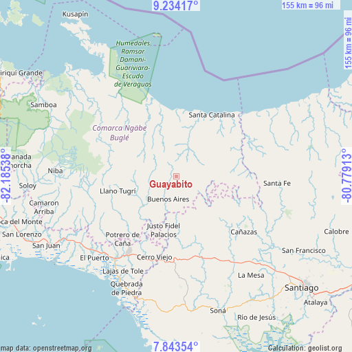
Guayabito GPS coordinates[2]
8° 32' 22.164" North, 81° 28' 56.1" West
| Map corner | latitude | longitude |
|---|---|---|
| Upper-left | 9.23417°, | -82.18538° |
| Center: | 8.53949°, | -81.48225° |
| Lower-right: | 7.84354°, | -80.77913° |
| Map W x H: | 154.6×154.6 km | = 96.1×96.1mi |
| max Lat: | 9.60898° ⇑42.1% North |
| Guayabito: | 8.53949° |
| min Lat: | ⇓57.9% South 7.26534° |
| min Long | Guayabito | max Long |
| -82.91275° | -81.48225° | -77.38965° |
| W 30.6%⇐ | ⇒69.4% E |
Elevation
Elevation of Guayabito is 1119 m = 3671 ft, and this is 946.9 m = 3107 ft above average elevation for this country.
| Max E: |
2103 m = 6900 ft | 1.6% |
| Guayabito | 1119 m 3671 ft | |
| Avg. | 172.1 m = 565 ft | |
Min E: |
-1 m = -3 ft | 98.4% |
See also: Panama elevation on elevation.city.
Geographical zone
Guayabito is located in North Torrid zone (between Equator and Tropic of Cancer). Distance of Equator is 949.5 km =590 mi to South.| Distance of | km | miles | from Guayabito |
|---|---|---|---|
| North Pole | 9057.6 | 5628.1 | to North |
| Arctic Circle | 6451.7 | 4008.9 | to North |
| Tropic Cancer | 1656.4 | 1029.2 | to North |
| Equator | 949.5 | 590 | to South |


Nearby cities:
15 places around Guayabito: (largest is in red/bold)
• Agua de Salud
4.3 km =2.7 mi,  152°
152°
• Bajo Solis
22 km =13.7 mi,  193°
193°
• Buabidi
24.8 km =15.4 mi,  253°
253°
• Buenos Aires
14 km =8.7 mi,  180°
180°
• Cerro Caña
25.2 km =15.7 mi,  214°
214°
• Cerro Plata
9.8 km =6.1 mi,  225°
225°
• El Bale
24.2 km =15 mi, 146°
• Güibale
13.5 km =8.4 mi,  102°
102°
• Llano Ñopo
20 km =12.4 mi, 228°
• Loma Yuca
21.6 km =13.4 mi,  23°
23°
• Peña Blanca
23.3 km =14.5 mi, 248°
• Río Grande
23.1 km =14.4 mi,  67°
67°
• San José
20.4 km =12.7 mi,  155°
155°
• Sitio Prado
21.5 km =13.4 mi, 210°
• Viguí
22.3 km =13.9 mi, 184°
Sources, notices
• [Note1] Compared only with cities in Panama existing in our database
• [Src1] Map data: © OpenStreetMap contributors (CC-BY-SA)
• [Src2] Other city data from geonames.org with taken over terms of usage.
• [Src3] Geographical zone / Annual Mean Temperature by Robert A. Rohde @ Wikipedia
