Boquerón geodata
Boquerón (Veraguas) is a seat of a third-order administrative division; located in Panama in America/Panama (GMT-5) time zone. With population of 38 people, there are 688 cities with bigger population in this country. Compared to other cities in Panama, 69.9% of cities are located further ↑North; 58.3% of cities are located further →East and 50.9% of cities have higher elevation than Boquerón. Note1


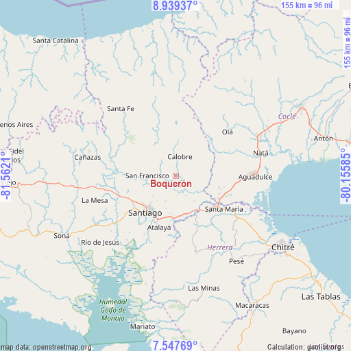
Boquerón GPS coordinates[2]
8° 14' 38.904" North, 80° 51' 32.292" West
| Map corner | latitude | longitude |
|---|---|---|
| Upper-left | 8.93937°, | -81.5621° |
| Center: | 8.24414°, | -80.85897° |
| Lower-right: | 7.54769°, | -80.15585° |
| Map W x H: | 154.7×154.7 km | = 96.1×96.1mi |
| max Lat: | 9.60898° ⇑69.9% North |
| Boquerón: | 8.24414° |
| min Lat: | ⇓30.1% South 7.26534° |
| min Long | Boquerón | max Long |
| -82.91275° | -80.85897° | -77.38965° |
| W 41.7%⇐ | ⇒58.3% E |
Elevation
Elevation of Boquerón is 70 m = 230 ft, and this is 102.1 m = 335 ft below average elevation for this country.
| Max E: |
2103 m = 6900 ft | 50.9% |
| Avg. | 172.1 m = 565 ft | |
| Boquerón | 70 m = 230 ft | |
Min E: |
-1 m = -3 ft | 49.1% |
See also: Panama elevation on elevation.city.
Geographical zone
Boquerón is located in North Torrid zone (between Equator and Tropic of Cancer). Distance of Equator is 916.7 km =569.6 mi to South.| Distance of | km | miles | from Boquerón |
|---|---|---|---|
| North Pole | 9090.4 | 5648.5 | to North |
| Arctic Circle | 6484.5 | 4029.3 | to North |
| Tropic Cancer | 1689.3 | 1049.7 | to North |
| Equator | 916.7 | 569.6 | to South |


Nearby cities:
15 places around Boquerón: (largest is in red/bold)
• Calobre
8.5 km =5.3 mi,  13°
13°
• Canto del Llano
17.6 km =10.9 mi,  220°
220°
• El Coclá
11 km =6.8 mi,  321°
321°
• El Espino
12.2 km =7.6 mi,  242°
242°
• El Espino de Santa Rosa
17.3 km =10.7 mi,  167°
167°
• El Pedernal
14.2 km =8.8 mi,  143°
143°
• El Peñón
17.5 km =10.9 mi,  312°
312°
• El Potrero
16.4 km =10.2 mi,  25°
25°
• La Mata
17.4 km =10.8 mi,  187°
187°
• La Raya de Calobre
4.7 km =2.9 mi,  131°
131°
• La Raya de Santa María
9.8 km =6.1 mi,  155°
155°
• Las Guías Abajo
12.7 km =7.9 mi,  115°
115°
• Los Higos
4.3 km =2.7 mi,  181°
181°
• Monjarás
14 km =8.7 mi,  356°
356°
• San Francisco
12.7 km =7.9 mi,  271°
271°
Sources, notices
• [Note1] Compared only with cities in Panama existing in our database
• [Src1] Map data: © OpenStreetMap contributors (CC-BY-SA)
• [Src2] Other city data from geonames.org with taken over terms of usage.
• [Src3] Geographical zone / Annual Mean Temperature by Robert A. Rohde @ Wikipedia
