Calobre geodata
Calobre (Veraguas) is a seat of a second-order administrative division; located in Panama in America/Panama (GMT-5) time zone. With population of 795 people, there are 325 cities with bigger population in this country. Compared to other cities in Panama, 65.4% of cities are located further ↑North; 57.7% of cities are located further →East and 65% of cities have lower elevation than Calobre. Note1


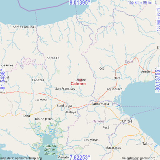
Calobre GPS coordinates[2]
8° 19' 7.896" North, 80° 50' 26.412" West
| Map corner | latitude | longitude |
|---|---|---|
| Upper-left | 9.01395°, | -81.5438° |
| Center: | 8.31886°, | -80.84067° |
| Lower-right: | 7.62253°, | -80.13755° |
| Map W x H: | 154.7×154.7 km | = 96.1×96.1mi |
| max Lat: | 9.60898° ⇑65.4% North |
| Calobre: | 8.31886° |
| min Lat: | ⇓34.6% South 7.26534° |
| min Long | Calobre | max Long |
| -82.91275° | -80.84067° | -77.38965° |
| W 42.3%⇐ | ⇒57.7% E |
Elevation
Elevation of Calobre is 125 m = 410 ft, and this is 47.1 m = 155 ft below average elevation for this country.
| Max E: |
2103 m = 6900 ft | 35% |
| Avg. | 172.1 m = 565 ft | |
| Calobre | 125 m = 410 ft | |
Min E: |
-1 m = -3 ft | 65% |
See also: Panama elevation on elevation.city.
Geographical zone
Calobre is located in North Torrid zone (between Equator and Tropic of Cancer). Distance of Equator is 925 km =574.8 mi to South.| Distance of | km | miles | from Calobre |
|---|---|---|---|
| North Pole | 9082.1 | 5643.4 | to North |
| Arctic Circle | 6476.2 | 4024.1 | to North |
| Tropic Cancer | 1680.9 | 1044.5 | to North |
| Equator | 925 | 574.8 | to South |


Nearby cities:
15 places around Calobre: (largest is in red/bold)
• Barnizal
11.8 km =7.3 mi,  36°
36°
• Boquerón
8.5 km =5.3 mi,  193°
193°
• El Coclá
8.8 km =5.5 mi,  271°
271°
• El Espino
19 km =11.8 mi,  222°
222°
• El Peñón
15.3 km =9.5 mi,  283°
283°
• El Potrero
8.2 km =5.1 mi, 38°
• La Laguna
12.4 km =7.7 mi,  79°
79°
• La Raya de Calobre
11.5 km =7.1 mi,  172°
172°
• La Raya de Santa María
17.3 km =10.7 mi, 172°
• La Yeguada
12.6 km =7.8 mi,  351°
351°
• Las Guías Abajo
16.7 km =10.4 mi,  145°
145°
• Los Higos
12.8 km =8 mi, 189°
• Monjarás
6.3 km =3.9 mi,  333°
333°
• San Francisco
16.8 km =10.4 mi,  241°
241°
• San José
16.9 km =10.5 mi,  13°
13°
Sources, notices
• [Note1] Compared only with cities in Panama existing in our database
• [Src1] Map data: © OpenStreetMap contributors (CC-BY-SA)
• [Src2] Other city data from geonames.org with taken over terms of usage.
• [Src3] Geographical zone / Annual Mean Temperature by Robert A. Rohde @ Wikipedia
