El Potrero geodata
El Potrero (Veraguas) is a seat of a third-order administrative division; located in Panama in America/Panama (GMT-5) time zone. With population of 168 people, there are 621 cities with bigger population in this country. Compared to other cities in Panama, 59.9% of cities are located further ↑North; 56.7% of cities are located further →East and 73.6% of cities have lower elevation than El Potrero. Note1


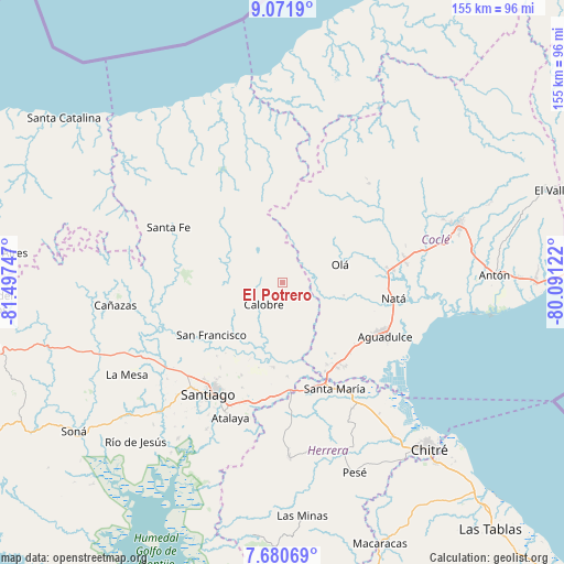
El Potrero GPS coordinates[2]
8° 22' 36.912" North, 80° 47' 39.624" West
| Map corner | latitude | longitude |
|---|---|---|
| Upper-left | 9.0719°, | -81.49747° |
| Center: | 8.37692°, | -80.79434° |
| Lower-right: | 7.68069°, | -80.09122° |
| Map W x H: | 154.7×154.7 km | = 96.1×96.1mi |
| max Lat: | 9.60898° ⇑59.9% North |
| El Potrero: | 8.37692° |
| min Lat: | ⇓40.1% South 7.26534° |
| min Long | El Potrero | max Long |
| -82.91275° | -80.79434° | -77.38965° |
| W 43.3%⇐ | ⇒56.7% E |
Elevation
Elevation of El Potrero is 181 m = 594 ft, and this is 8.9 m = 29 ft above average elevation for this country.
| Max E: |
2103 m = 6900 ft | 26.4% |
| El Potrero | 181 m 594 ft | |
| Avg. | 172.1 m = 565 ft | |
Min E: |
-1 m = -3 ft | 73.6% |
See also: Panama elevation on elevation.city.
Geographical zone
El Potrero is located in North Torrid zone (between Equator and Tropic of Cancer). Distance of Equator is 931.4 km =578.7 mi to South.| Distance of | km | miles | from El Potrero |
|---|---|---|---|
| North Pole | 9075.6 | 5639.3 | to North |
| Arctic Circle | 6469.7 | 4020.1 | to North |
| Tropic Cancer | 1674.5 | 1040.5 | to North |
| Equator | 931.4 | 578.7 | to South |


Nearby cities:
15 places around El Potrero: (largest is in red/bold)
• Barnizal
3.6 km =2.2 mi,  30°
30°
• Barranco Colorado
17.5 km =10.9 mi,  85°
85°
• Boquerón
16.4 km =10.2 mi,  205°
205°
• Calobre
8.2 km =5.1 mi,  218°
218°
• El Coclá
15.2 km =9.4 mi,  246°
246°
• El Copé
14.3 km =8.9 mi,  61°
61°
• El Peñón
20.2 km =12.6 mi,  261°
261°
• La Laguna
8.3 km =5.2 mi,  120°
120°
• La Raya de Calobre
18.2 km =11.3 mi,  191°
191°
• La Yeguada
9.2 km =5.7 mi,  310°
310°
• Las Huacas del Quije
11.1 km =6.9 mi, 25°
• Monjarás
8 km =5 mi, 264°
• Olá
16.4 km =10.2 mi,  73°
73°
• San José
10.1 km =6.3 mi,  353°
353°
• Toza
17.3 km =10.7 mi,  101°
101°
Sources, notices
• [Note1] Compared only with cities in Panama existing in our database
• [Src1] Map data: © OpenStreetMap contributors (CC-BY-SA)
• [Src2] Other city data from geonames.org with taken over terms of usage.
• [Src3] Geographical zone / Annual Mean Temperature by Robert A. Rohde @ Wikipedia
