Miramar geodata
Miramar (Bocas del Toro) is a seat of a third-order administrative division; located in Panama in America/Panama (GMT-5) time zone. With population of 346 people, there are 543 cities with bigger population in this country. Compared to other cities in Panama, 83.6% of cities are located further ↓South; 81.5% of cities are located further →East and 90.4% of cities have higher elevation than Miramar. Note1


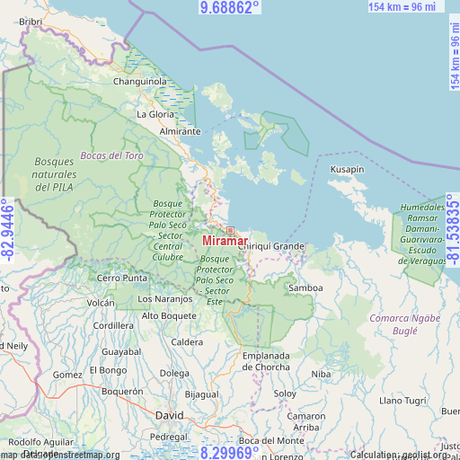
Miramar GPS coordinates[2]
8° 59' 41.352" North, 82° 14' 29.292" West
| Map corner | latitude | longitude |
|---|---|---|
| Upper-left | 9.68862°, | -82.9446° |
| Center: | 8.99482°, | -82.24147° |
| Lower-right: | 8.29969°, | -81.53835° |
| Map W x H: | 154.4×154.4 km | = 95.9×95.9mi |
| max Lat: | 9.60898° ⇑16.4% North |
| Miramar: | 8.99482° |
| min Lat: | ⇓83.6% South 7.26534° |
| min Long | Miramar | max Long |
| -82.91275° | -82.24147° | -77.38965° |
| W 18.5%⇐ | ⇒81.5% E |
Elevation
Elevation of Miramar is 12 m = 39 ft, and this is 160.1 m = 525 ft below average elevation for this country.
| Max E: |
2103 m = 6900 ft | 90.4% |
| Avg. | 172.1 m = 565 ft | |
| Miramar | 12 m = 39 ft | |
Min E: |
-1 m = -3 ft | 9.6% |
See also: Panama elevation on elevation.city.
Geographical zone
Miramar is located in North Torrid zone (between Equator and Tropic of Cancer). Distance of Equator is 1000.1 km =621.4 mi to South.| Distance of | km | miles | from Miramar |
|---|---|---|---|
| North Pole | 9006.9 | 5596.6 | to North |
| Arctic Circle | 6401 | 3977.4 | to North |
| Tropic Cancer | 1605.8 | 997.8 | to North |
| Equator | 1000.1 | 621.4 | to South |


Nearby cities:
15 places around Miramar: (largest is in red/bold)
• Alto Lino
30.4 km =18.9 mi,  224°
224°
• Cauchero
17.7 km =11 mi,  351°
351°
• Cayo de Agua
26.8 km =16.7 mi,  49°
49°
• Chiriquí Grande
14.7 km =9.1 mi,  111°
111°
• Isla Tigre
26.7 km =16.6 mi,  41°
41°
• Jaramillo Arriba
29.7 km =18.5 mi, 222°
• Los Chiricanos
3.5 km =2.2 mi,  122°
122°
• Norteño
8.1 km =5 mi,  276°
276°
• Pueblo Nuevo
12.8 km =8 mi,  171°
171°
• Punta Laurel
20.5 km =12.7 mi, 37°
• Punta Peña
10.7 km =6.6 mi,  144°
144°
• Punta Róbalo
4.7 km =2.9 mi, 349°
• Quebrada Pastor
27.3 km =17 mi,  331°
331°
• Quebrada Tula
31.9 km =19.8 mi, 122°
• Rámbala
10.6 km =6.6 mi, 141°
Sources, notices
• [Note1] Compared only with cities in Panama existing in our database
• [Src1] Map data: © OpenStreetMap contributors (CC-BY-SA)
• [Src2] Other city data from geonames.org with taken over terms of usage.
• [Src3] Geographical zone / Annual Mean Temperature by Robert A. Rohde @ Wikipedia
