Pásiga geodata
Pásiga (Panamá) is a seat of a third-order administrative division; located in Panama in America/Panama (GMT-5) time zone. With population of 77 people, there are 673 cities with bigger population in this country. Compared to other cities in Panama, 80.9% of cities are located further ↓South; 92.6% of cities are located further ←West and 64.6% of cities have higher elevation than Pásiga. Note1


Pásiga GPS coordinates[2]
8° 56' 11.292" North, 78° 54' 33.012" West
| Map corner | latitude | longitude |
|---|---|---|
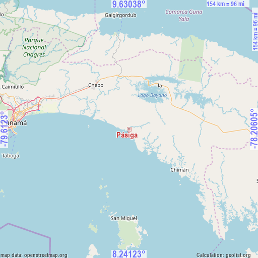
| Upper-left | 9.63038°, | -79.6123° |
| Center: | 8.93647°, | -78.90917° |
| Lower-right: | 8.24123°, | -78.20605° |
| Map W x H: | 154.5×154.5 km | = 96×96mi |
| max Lat: | 9.60898° ⇑19.1% North |
| Pásiga: | 8.93647° |
| min Lat: | ⇓80.9% South 7.26534° |
| min Long | Pásiga | max Long |
| -82.91275° | -78.90917° | -77.38965° |
| W 92.6%⇐ | ⇒7.4% E |
Elevation
Elevation of Pásiga is 45 m = 148 ft, and this is 127.1 m = 417 ft below average elevation for this country.
| Max E: |
2103 m = 6900 ft | 64.6% |
| Avg. | 172.1 m = 565 ft | |
| Pásiga | 45 m = 148 ft | |
Min E: |
-1 m = -3 ft | 35.4% |
See also: Panama elevation on elevation.city.
Geographical zone
Pásiga is located in North Torrid zone (between Equator and Tropic of Cancer). Distance of Equator is 993.6 km =617.4 mi to South.| Distance of | km | miles | from Pásiga |
|---|---|---|---|
| North Pole | 9013.4 | 5600.7 | to North |
| Arctic Circle | 6407.5 | 3981.4 | to North |
| Tropic Cancer | 1612.3 | 1001.8 | to North |
| Equator | 993.6 | 617.4 | to South |


Nearby cities:
15 places around Pásiga: (largest is in red/bold)
• Cañita
31.8 km =19.8 mi,  2°
2°
• Chepillo
24.2 km =15 mi,  274°
274°
• Chepo
33.4 km =20.8 mi,  320°
320°
• Chimán
40.6 km =25.2 mi,  132°
132°
• Contadora
37.4 km =23.2 mi,  202°
202°
• El Progreso
43.2 km =26.8 mi,  328°
328°
• Icantí
39.6 km =24.6 mi,  38°
38°
• Ipetí
44.5 km =27.7 mi,  85°
85°
• Juan Gil
46.6 km =29 mi,  305°
305°
• Las Margaritas
33.8 km =21 mi, 324°
• Naranjal
41.3 km =25.7 mi,  301°
301°
• Pacora
44.7 km =27.8 mi,  290°
290°
• Paso Blanco
42.5 km =26.4 mi, 299°
• Unión Santeña
30.5 km =19 mi,  111°
111°
• Unión de Azuero
37.4 km =23.2 mi, 309°
Sources, notices
• [Note1] Compared only with cities in Panama existing in our database
• [Src1] Map data: © OpenStreetMap contributors (CC-BY-SA)
• [Src2] Other city data from geonames.org with taken over terms of usage.
• [Src3] Geographical zone / Annual Mean Temperature by Robert A. Rohde @ Wikipedia
