Ipetí geodata
Ipetí (Panamá) is a populated place; located in Panama in America/Panama (GMT-5) time zone. With population of 652 people, there are 382 cities with bigger population in this country. Compared to other cities in Panama, 82.6% of cities are located further ↓South; 93.7% of cities are located further ←West and 56.4% of cities have lower elevation than Ipetí. Note1


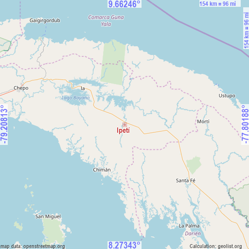
Ipetí GPS coordinates[2]
8° 58' 6.996" North, 78° 30' 18" West
| Map corner | latitude | longitude |
|---|---|---|
| Upper-left | 9.66246°, | -79.20813° |
| Center: | 8.96861°, | -78.505° |
| Lower-right: | 8.27343°, | -77.80188° |
| Map W x H: | 154.4×154.4 km | = 95.9×95.9mi |
| max Lat: | 9.60898° ⇑17.4% North |
| Ipetí: | 8.96861° |
| min Lat: | ⇓82.6% South 7.26534° |
| min Long | Ipetí | max Long |
| -82.91275° | -78.505° | -77.38965° |
| W 93.7%⇐ | ⇒6.3% E |
Elevation
Elevation of Ipetí is 92 m = 302 ft, and this is 80.1 m = 263 ft below average elevation for this country.
| Max E: |
2103 m = 6900 ft | 43.6% |
| Avg. | 172.1 m = 565 ft | |
| Ipetí | 92 m = 302 ft | |
Min E: |
-1 m = -3 ft | 56.4% |
See also: Panama elevation on elevation.city.
Geographical zone
Ipetí is located in North Torrid zone (between Equator and Tropic of Cancer). Distance of Equator is 997.2 km =619.6 mi to South.| Distance of | km | miles | from Ipetí |
|---|---|---|---|
| North Pole | 9009.8 | 5598.4 | to North |
| Arctic Circle | 6404 | 3979.3 | to North |
| Tropic Cancer | 1608.7 | 999.6 | to North |
| Equator | 997.2 | 619.6 | to South |


Nearby cities:
15 places around Ipetí: (largest is in red/bold)
• Agua Fría Número Uno
35.9 km =22.3 mi,  109°
109°
• Barriales
44.6 km =27.7 mi,  163°
163°
• Brujas
42.7 km =26.5 mi,  183°
183°
• Cañazas
31.8 km =19.8 mi,  104°
104°
• Cañita
51.3 km =31.9 mi,  303°
303°
• Chimán
34 km =21.1 mi,  204°
204°
• Icantí
33.6 km =20.9 mi,  324°
324°
• Isla Tigre
51.4 km =31.9 mi,  358°
358°
• Platanilla
20.5 km =12.7 mi,  139°
139°
• Playón Chico
48.4 km =30.1 mi,  38°
38°
• Pásiga
44.5 km =27.7 mi,  265°
265°
• Santa Fé
51.4 km =31.9 mi,  132°
132°
• Tortí
12.1 km =7.5 mi,  115°
115°
• Ualá
48.8 km =30.3 mi,  87°
87°
• Unión Santeña
21.8 km =13.5 mi,  227°
227°
Sources, notices
• [Note1] Compared only with cities in Panama existing in our database
• [Src1] Map data: © OpenStreetMap contributors (CC-BY-SA)
• [Src2] Other city data from geonames.org with taken over terms of usage.
• [Src3] Geographical zone / Annual Mean Temperature by Robert A. Rohde @ Wikipedia
