Contadora geodata
Contadora (Panamá) is a seat of a third-order administrative division; located in Panama in America/Panama (GMT-5) time zone. With population of 253 people, there are 574 cities with bigger population in this country. Compared to other cities in Panama, 65.6% of cities are located further ↓South; 91.7% of cities are located further ←West and 77.8% of cities have higher elevation than Contadora. Note1


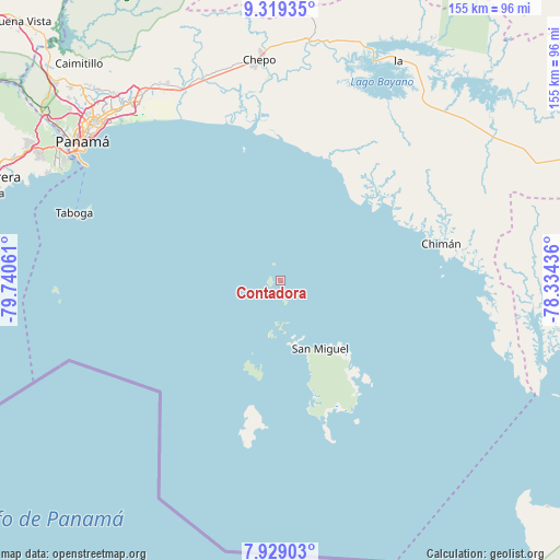
Contadora GPS coordinates[2]
8° 37' 29.388" North, 79° 2' 14.928" West
| Map corner | latitude | longitude |
|---|---|---|
| Upper-left | 9.31935°, | -79.74061° |
| Center: | 8.62483°, | -79.03748° |
| Lower-right: | 7.92903°, | -78.33436° |
| Map W x H: | 154.6×154.6 km | = 96.1×96.1mi |
| max Lat: | 9.60898° ⇑34.4% North |
| Contadora: | 8.62483° |
| min Lat: | ⇓65.6% South 7.26534° |
| min Long | Contadora | max Long |
| -82.91275° | -79.03748° | -77.38965° |
| W 91.7%⇐ | ⇒8.3% E |
Elevation
Elevation of Contadora is 26 m = 85 ft, and this is 146.1 m = 479 ft below average elevation for this country.
| Max E: |
2103 m = 6900 ft | 77.8% |
| Avg. | 172.1 m = 565 ft | |
| Contadora | 26 m = 85 ft | |
Min E: |
-1 m = -3 ft | 22.2% |
See also: Panama elevation on elevation.city.
Geographical zone
Contadora is located in North Torrid zone (between Equator and Tropic of Cancer). Distance of Equator is 959 km =595.9 mi to South.| Distance of | km | miles | from Contadora |
|---|---|---|---|
| North Pole | 9048.1 | 5622.2 | to North |
| Arctic Circle | 6442.2 | 4003 | to North |
| Tropic Cancer | 1646.9 | 1023.3 | to North |
| Equator | 959 | 595.9 | to South |


Nearby cities:
15 places around Contadora: (largest is in red/bold)
• Brujas
56 km =34.8 mi,  94°
94°
• Chepillo
37.9 km =23.5 mi,  344°
344°
• Chepo
61 km =37.9 mi,  353°
353°
• Chimán
44.8 km =27.8 mi,  80°
80°
• La Ensenada
35.6 km =22.1 mi,  143°
143°
• La Esmeralda
41.6 km =25.8 mi,  162°
162°
• La Guinea
33.4 km =20.8 mi, 160°
• Naranjal
59.9 km =37.2 mi, 339°
• Pacora
57.7 km =35.9 mi,  331°
331°
• Paso Blanco
60.4 km =37.5 mi, 337°
• Pásiga
37.4 km =23.2 mi,  22°
22°
• San Miguel
21.7 km =13.5 mi,  149°
149°
• Taboga
59.9 km =37.2 mi,  288°
288°
• Unión Santeña
48.5 km =30.1 mi,  61°
61°
• Unión de Azuero
60.5 km =37.6 mi, 346°
Sources, notices
• [Note1] Compared only with cities in Panama existing in our database
• [Src1] Map data: © OpenStreetMap contributors (CC-BY-SA)
• [Src2] Other city data from geonames.org with taken over terms of usage.
• [Src3] Geographical zone / Annual Mean Temperature by Robert A. Rohde @ Wikipedia
