Chimán geodata
Chimán (Panamá) is a seat of a second-order administrative division; located in Panama in America/Panama (GMT-5) time zone. With population of 786 people, there are 328 cities with bigger population in this country. Compared to other cities in Panama, 69.8% of cities are located further ↓South; 93.2% of cities are located further ←West and 92.8% of cities have higher elevation than Chimán. Note1


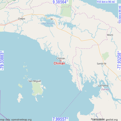
Chimán GPS coordinates[2]
8° 41' 28.5" North, 78° 38' 8.52" West
| Map corner | latitude | longitude |
|---|---|---|
| Upper-left | 9.38564°, | -79.33883° |
| Center: | 8.69125°, | -78.6357° |
| Lower-right: | 7.99557°, | -77.93258° |
| Map W x H: | 154.6×154.6 km | = 96.1×96.1mi |
| max Lat: | 9.60898° ⇑30.2% North |
| Chimán: | 8.69125° |
| min Lat: | ⇓69.8% South 7.26534° |
| min Long | Chimán | max Long |
| -82.91275° | -78.6357° | -77.38965° |
| W 93.2%⇐ | ⇒6.8% E |
Elevation
Elevation of Chimán is 10 m = 33 ft, and this is 162.1 m = 532 ft below average elevation for this country.
| Max E: |
2103 m = 6900 ft | 92.8% |
| Avg. | 172.1 m = 565 ft | |
| Chimán | 10 m = 33 ft | |
Min E: |
-1 m = -3 ft | 7.2% |
See also: Panama elevation on elevation.city.
Geographical zone
Chimán is located in North Torrid zone (between Equator and Tropic of Cancer). Distance of Equator is 966.4 km =600.5 mi to South.| Distance of | km | miles | from Chimán |
|---|---|---|---|
| North Pole | 9040.7 | 5617.6 | to North |
| Arctic Circle | 6434.8 | 3998.4 | to North |
| Tropic Cancer | 1639.5 | 1018.7 | to North |
| Equator | 966.4 | 600.5 | to South |


Nearby cities:
15 places around Chimán: (largest is in red/bold)
• Agua Fría Número Uno
51.6 km =32.1 mi,  68°
68°
• Barriales
29.7 km =18.5 mi,  113°
113°
• Brujas
16.5 km =10.3 mi,  135°
135°
• Cañazas
50.7 km =31.5 mi,  62°
62°
• Contadora
44.8 km =27.8 mi,  260°
260°
• Cucunatí
43.6 km =27.1 mi, 107°
• Gonzalo Vásquez
36.5 km =22.7 mi,  147°
147°
• Ipetí
34 km =21.1 mi,  24°
24°
• La Ensenada
42.9 km =26.7 mi,  212°
212°
• La Guinea
50.8 km =31.6 mi,  220°
220°
• Platanilla
31.5 km =19.6 mi, 61°
• Pásiga
40.6 km =25.2 mi,  312°
312°
• San Miguel
42.1 km =26.2 mi,  231°
231°
• Tortí
36 km =22.4 mi,  44°
44°
• Unión Santeña
16.1 km =10 mi,  353°
353°
Sources, notices
• [Note1] Compared only with cities in Panama existing in our database
• [Src1] Map data: © OpenStreetMap contributors (CC-BY-SA)
• [Src2] Other city data from geonames.org with taken over terms of usage.
• [Src3] Geographical zone / Annual Mean Temperature by Robert A. Rohde @ Wikipedia
