Armila geodata
Armila (Guna Yala) is a populated place; located in Panama in America/Panama (GMT-5) time zone. With population of 637 people, there are 392 cities with bigger population in this country. Compared to other cities in Panama, 68.4% of cities are located further ↓South; 99.7% of cities are located further ←West and 96.3% of cities have higher elevation than Armila. Note1


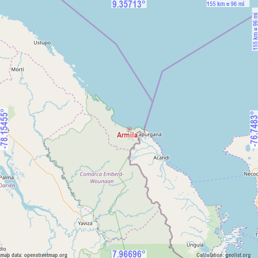
Armila GPS coordinates[2]
8° 39' 45.684" North, 77° 27' 5.112" West
| Map corner | latitude | longitude |
|---|---|---|
| Upper-left | 9.35713°, | -78.15455° |
| Center: | 8.66269°, | -77.45142° |
| Lower-right: | 7.96696°, | -76.7483° |
| Map W x H: | 154.6×154.6 km | = 96.1×96.1mi |
| max Lat: | 9.60898° ⇑31.6% North |
| Armila: | 8.66269° |
| min Lat: | ⇓68.4% South 7.26534° |
| min Long | Armila | max Long |
| -82.91275° | -77.45142° | -77.38965° |
| W 99.7%⇐ | ⇒0.3% E |
Elevation
Elevation of Armila is 6 m = 20 ft, and this is 166.1 m = 545 ft below average elevation for this country.
| Max E: |
2103 m = 6900 ft | 96.3% |
| Avg. | 172.1 m = 565 ft | |
| Armila | 6 m = 20 ft | |
Min E: |
-1 m = -3 ft | 3.7% |
See also: Panama elevation on elevation.city.
Geographical zone
Armila is located in North Torrid zone (between Equator and Tropic of Cancer). Distance of Equator is 963.2 km =598.5 mi to South.| Distance of | km | miles | from Armila |
|---|---|---|---|
| North Pole | 9043.9 | 5619.6 | to North |
| Arctic Circle | 6438 | 4000.4 | to North |
| Tropic Cancer | 1642.7 | 1020.7 | to North |
| Equator | 963.2 | 598.5 | to South |


Nearby cities:
15 places around Armila: (largest is in red/bold)
• Coetupo
37.4 km =23.2 mi,  314°
314°
• Corozal
53.7 km =33.4 mi,  197°
197°
• El Real de Santa María
65.7 km =40.8 mi,  205°
205°
• Lajas Blancas
48.3 km =30 mi,  235°
235°
• Metetí
60.8 km =37.8 mi,  252°
252°
• Mortí
55.3 km =34.4 mi,  292°
292°
• Mortí
61 km =37.9 mi, 289°
• Mulatupo
45.6 km =28.3 mi, 313°
• Pueblo Nuevo
63 km =39.1 mi, 205°
• Puerto Obaldía
3.6 km =2.2 mi,  83°
83°
• Tubualá
41.5 km =25.8 mi, 313°
• Unión Chocó
65 km =40.4 mi,  188°
188°
• Villa Darién
62.6 km =38.9 mi,  257°
257°
• Yape
64.8 km =40.3 mi, 194°
• Yaviza
62 km =38.5 mi, 205°
Sources, notices
• [Note1] Compared only with cities in Panama existing in our database
• [Src1] Map data: © OpenStreetMap contributors (CC-BY-SA)
• [Src2] Other city data from geonames.org with taken over terms of usage.
• [Src3] Geographical zone / Annual Mean Temperature by Robert A. Rohde @ Wikipedia
