Vista Alegre geodata
Vista Alegre (Amazonas) is a seat of a third-order administrative division; located in Peru in America/Lima (GMT-5) time zone. In our database, there are 305 cities with bigger population. Compared to other cities in Peru, 88.6% of cities are located further ↓South; 70.5% of cities are located further →East and 69.4% of cities have higher elevation than Vista Alegre. Note1
Administrative division(s):
- Level 1: Amazonas
- Level 2: Provincia de Rodríguez de Mendoza
- Level 3: Vista Alegre


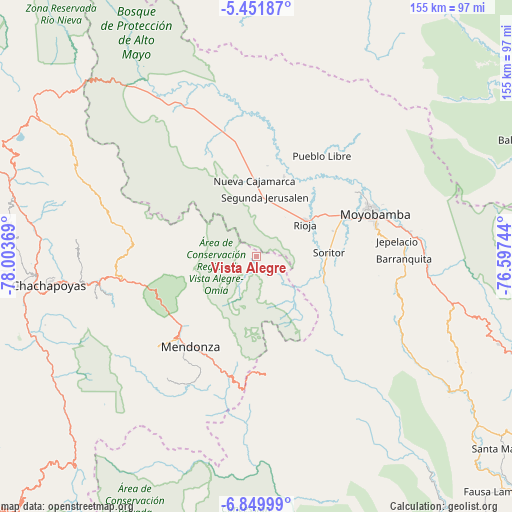
Vista Alegre GPS coordinates[2]
6° 9' 5.004" South, 77° 18' 2.016" West
| Map corner | latitude | longitude |
|---|---|---|
| Upper-left | -5.45187°, | -78.00369° |
| Center: | -6.15139°, | -77.30056° |
| Lower-right: | -6.84999°, | -76.59744° |
| Map W x H: | 155.5×155.5 km | = 96.6×96.6mi |
| max Lat: | -0.96667° ⇑11.4% North |
| Vista Alegre: | -6.15139° |
| min Lat: | ⇓88.6% South -18.01465° |
| min Long | Vista Alegre | max Long |
| -81.30472° | -77.30056° | -69.04167° |
| W 29.5%⇐ | ⇒70.5% E |
Elevation
Elevation of Vista Alegre is 1545 m = 5069 ft, and this is 773.7 m = 2538 ft below average elevation for this country.
| Max E: |
5022 m = 16476 ft | 69.4% |
| Avg. | 2318.7 m = 7607 ft | |
| Vista Alegre | 1545 m = 5069 ft | |
Min E: |
1 m = 3 ft | 30.6% |
See also: Peru elevation on elevation.city.
Geographical zone
Vista Alegre is located in South Torrid zone (between Equator and Tropic of Capricorn). Distance of Equator is 684 km =425 mi to North.| Distance of | km | miles | from Vista Alegre |
|---|---|---|---|
| Equator | 684 | 425 | to North |
| Tropic Capricorn | 1921.9 | 1194.2 | to South |
| Antarctic Circle | 6717.2 | 4173.9 | to South |
| South Pole | 9323.1 | 5793.1 | to South |


Nearby cities:
15 places around Vista Alegre: (largest is in red/bold)
• Bajo Naranjillo
38.5 km =23.9 mi,  346°
346°
• Calzada
29.1 km =18.1 mi,  62°
62°
• Granada
36.5 km =22.7 mi,  279°
279°
• Habana
24.4 km =15.2 mi,  71°
71°
• Jepelacio
38.9 km =24.2 mi,  84°
84°
• Longar
37.3 km =23.2 mi,  226°
226°
• Mendoza
33.6 km =20.9 mi,  216°
216°
• Moyobamba
38.6 km =24 mi, 70°
• Nueva Cajamarca
23.5 km =14.6 mi,  357°
357°
• Omia
36.8 km =22.9 mi,  196°
196°
• Posic
21.5 km =13.4 mi,  44°
44°
• Rioja
18.2 km =11.3 mi,  54°
54°
• Soritor
21.8 km =13.5 mi,  86°
86°
• Yorongos
17.4 km =10.8 mi, 85°
• Yuracyacu
25.8 km =16 mi,  18°
18°
Sources, notices
• [Note1] Compared only with cities in Peru existing in our database
• [Src1] Map data: © OpenStreetMap contributors (CC-BY-SA)
• [Src2] Other city data from geonames.org with taken over terms of usage.
• [Src3] Geographical zone / Annual Mean Temperature by Robert A. Rohde @ Wikipedia
