Granada geodata
Granada (Amazonas) is a seat of a third-order administrative division; located in Peru in America/Lima (GMT-5) time zone. In our database, there are 305 cities with bigger population. Compared to other cities in Peru, 89.2% of cities are located further ↓South; 75.1% of cities are located further →East and 53.8% of cities have lower elevation than Granada. Note1


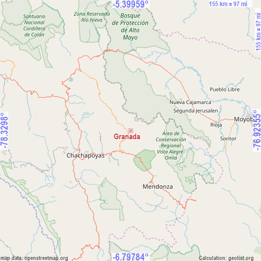
Granada GPS coordinates[2]
6° 5' 57.012" South, 77° 37' 36.012" West
| Map corner | latitude | longitude |
|---|---|---|
| Upper-left | -5.39959°, | -78.3298° |
| Center: | -6.09917°, | -77.62667° |
| Lower-right: | -6.79784°, | -76.92355° |
| Map W x H: | 155.5×155.5 km | = 96.6×96.6mi |
| max Lat: | -0.96667° ⇑10.8% North |
| Granada: | -6.09917° |
| min Lat: | ⇓89.2% South -18.01465° |
| min Long | Granada | max Long |
| -81.30472° | -77.62667° | -69.04167° |
| W 24.9%⇐ | ⇒75.1% E |
Elevation
Elevation of Granada is 2993 m = 9820 ft, and this is 674.3 m = 2212 ft above average elevation for this country.
| Max E: |
5022 m = 16476 ft | 46.2% |
| Granada | 2993 m 9820 ft | |
| Avg. | 2318.7 m = 7607 ft | |
Min E: |
1 m = 3 ft | 53.8% |
See also: Peru elevation on elevation.city.
Geographical zone
Granada is located in South Torrid zone (between Equator and Tropic of Capricorn). Distance of Equator is 678.2 km =421.4 mi to North.| Distance of | km | miles | from Granada |
|---|---|---|---|
| Equator | 678.2 | 421.4 | to North |
| Tropic Capricorn | 1927.8 | 1197.9 | to South |
| Antarctic Circle | 6723 | 4177.5 | to South |
| South Pole | 9328.9 | 5796.7 | to South |


Nearby cities:
15 places around Granada: (largest is in red/bold)
• Chachapoyas
30.6 km =19 mi,  241°
241°
• Cheto
19.3 km =12 mi,  204°
204°
• Chisquilla
26.7 km =16.6 mi,  333°
333°
• Cochamal
34.5 km =21.4 mi,  172°
172°
• Daguas
19 km =11.8 mi,  221°
221°
• Huancas
27.7 km =17.2 mi,  252°
252°
• Lamud
36.4 km =22.6 mi,  263°
263°
• Longar
32.8 km =20.4 mi,  164°
164°
• Luya
36 km =22.4 mi, 258°
• Mendoza
36.5 km =22.7 mi,  153°
153°
• Olleros
6 km =3.7 mi,  339°
339°
• Olto
36.8 km =22.9 mi,  269°
269°
• Quinjalca
5.7 km =3.5 mi,  277°
277°
• Soloco
22.3 km =13.9 mi, 215°
• Vista Alegre
36.5 km =22.7 mi,  99°
99°
Sources, notices
• [Note1] Compared only with cities in Peru existing in our database
• [Src1] Map data: © OpenStreetMap contributors (CC-BY-SA)
• [Src2] Other city data from geonames.org with taken over terms of usage.
• [Src3] Geographical zone / Annual Mean Temperature by Robert A. Rohde @ Wikipedia
