Calzada geodata
Calzada (San Martín) is a seat of a third-order administrative division; located in Peru in America/Lima (GMT-5) time zone. In our database, there are 305 cities with bigger population. Compared to other cities in Peru, 90% of cities are located further ↓South; 68% of cities are located further →East and 73.8% of cities have higher elevation than Calzada. Note1


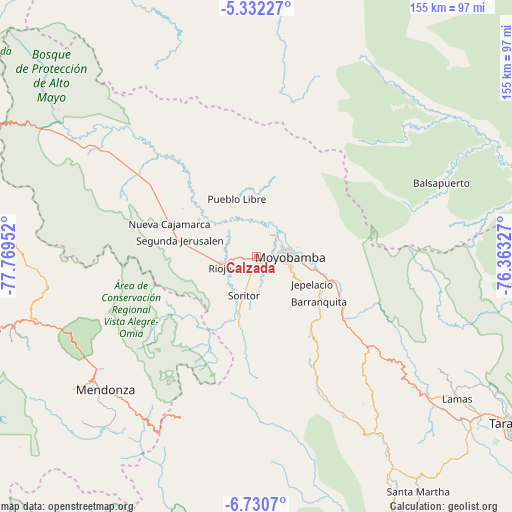
Calzada GPS coordinates[2]
6° 1' 54.984" South, 77° 3' 59.004" West
| Map corner | latitude | longitude |
|---|---|---|
| Upper-left | -5.33227°, | -77.76952° |
| Center: | -6.03194°, | -77.06639° |
| Lower-right: | -6.7307°, | -76.36327° |
| Map W x H: | 155.5×155.5 km | = 96.6×96.6mi |
| max Lat: | -0.96667° ⇑10% North |
| Calzada: | -6.03194° |
| min Lat: | ⇓90% South -18.01465° |
| min Long | Calzada | max Long |
| -81.30472° | -77.06639° | -69.04167° |
| W 32%⇐ | ⇒68% E |
Elevation
Elevation of Calzada is 849 m = 2785 ft, and this is 1469.7 m = 4822 ft below average elevation for this country.
| Max E: |
5022 m = 16476 ft | 73.8% |
| Avg. | 2318.7 m = 7607 ft | |
| Calzada | 849 m = 2785 ft | |
Min E: |
1 m = 3 ft | 26.2% |
See also: Peru elevation on elevation.city.
Geographical zone
Calzada is located in South Torrid zone (between Equator and Tropic of Capricorn). Distance of Equator is 670.7 km =416.8 mi to North.| Distance of | km | miles | from Calzada |
|---|---|---|---|
| Equator | 670.7 | 416.8 | to North |
| Tropic Capricorn | 1935.2 | 1202.5 | to South |
| Antarctic Circle | 6730.5 | 4182.1 | to South |
| South Pole | 9336.4 | 5801.4 | to South |


Nearby cities:
15 places around Calzada: (largest is in red/bold)
• Bajo Naranjillo
42.5 km =26.4 mi,  304°
304°
• Habana
6.2 km =3.9 mi,  206°
206°
• Jepelacio
15.9 km =9.9 mi,  126°
126°
• Moyobamba
10.5 km =6.5 mi,  91°
91°
• Naranjos
57.5 km =35.7 mi, 304°
• Nueva Cajamarca
28.6 km =17.8 mi,  290°
290°
• Omia
60.6 km =37.7 mi,  216°
216°
• Posic
10.9 km =6.8 mi,  280°
280°
• Rioja
11.4 km =7.1 mi,  256°
256°
• Roque
50.4 km =31.3 mi,  144°
144°
• Soritor
12.6 km =7.8 mi,  199°
199°
• Tabalosos
55.2 km =34.3 mi, 129°
• Vista Alegre
29.1 km =18.1 mi,  242°
242°
• Yorongos
14.7 km =9.1 mi, 215°
• Yuracyacu
21 km =13 mi, 302°
Sources, notices
• [Note1] Compared only with cities in Peru existing in our database
• [Src1] Map data: © OpenStreetMap contributors (CC-BY-SA)
• [Src2] Other city data from geonames.org with taken over terms of usage.
• [Src3] Geographical zone / Annual Mean Temperature by Robert A. Rohde @ Wikipedia
