Tabalosos geodata
Tabalosos (San Martín) is a seat of a third-order administrative division; located in Peru in America/Lima (GMT-5) time zone. With population of 14,744 people, there are 110 cities with bigger population in this country. Compared to other cities in Peru, 86.9% of cities are located further ↓South; 62% of cities are located further →East and 71.4% of cities have higher elevation than Tabalosos. Note1


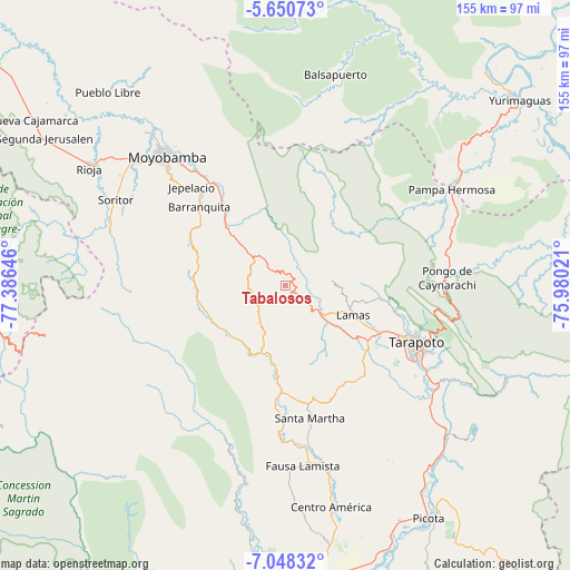
Tabalosos GPS coordinates[2]
6° 21' 0" South, 76° 40' 59.988" West
| Map corner | latitude | longitude |
|---|---|---|
| Upper-left | -5.65073°, | -77.38646° |
| Center: | -6.35°, | -76.68333° |
| Lower-right: | -7.04832°, | -75.98021° |
| Map W x H: | 155.4×155.4 km | = 96.6×96.6mi |
| max Lat: | -0.96667° ⇑13.1% North |
| Tabalosos: | -6.35° |
| min Lat: | ⇓86.9% South -18.01465° |
| min Long | Tabalosos | max Long |
| -81.30472° | -76.68333° | -69.04167° |
| W 38%⇐ | ⇒62% E |
Elevation
Elevation of Tabalosos is 1162 m = 3812 ft, and this is 1156.7 m = 3795 ft below average elevation for this country.
| Max E: |
5022 m = 16476 ft | 71.4% |
| Avg. | 2318.7 m = 7607 ft | |
| Tabalosos | 1162 m = 3812 ft | |
Min E: |
1 m = 3 ft | 28.6% |
See also: Peru elevation on elevation.city.
Geographical zone
Tabalosos is located in South Torrid zone (between Equator and Tropic of Capricorn). Distance of Equator is 706.1 km =438.8 mi to North.| Distance of | km | miles | from Tabalosos |
|---|---|---|---|
| Equator | 706.1 | 438.8 | to North |
| Tropic Capricorn | 1899.9 | 1180.5 | to South |
| Antarctic Circle | 6695.1 | 4160.1 | to South |
| South Pole | 9301 | 5779.4 | to South |


Nearby cities:
15 places around Tabalosos: (largest is in red/bold)
• Agua Blanca
41.5 km =25.8 mi,  181°
181°
• Cuñumbuqui
28.7 km =17.8 mi,  128°
128°
• Jepelacio
39.3 km =24.4 mi,  311°
311°
• Juan Guerra
46.8 km =29.1 mi,  123°
123°
• Lamas
18.2 km =11.3 mi,  114°
114°
• Moyobamba
47.4 km =29.5 mi,  317°
317°
• Roque
14 km =8.7 mi,  246°
246°
• San Antonio
36.9 km =22.9 mi,  92°
92°
• Santa Rosa
37.8 km =23.5 mi,  168°
168°
• Shapaja
53 km =32.9 mi, 118°
• Shatoja
20.2 km =12.6 mi,  191°
191°
• Sisa
29 km =18 mi, 182°
• Soritor
52.1 km =32.4 mi,  296°
296°
• Tarapoto
38.9 km =24.2 mi, 115°
• Zapatero
29 km =18 mi, 133°
Sources, notices
• [Note1] Compared only with cities in Peru existing in our database
• [Src1] Map data: © OpenStreetMap contributors (CC-BY-SA)
• [Src2] Other city data from geonames.org with taken over terms of usage.
• [Src3] Geographical zone / Annual Mean Temperature by Robert A. Rohde @ Wikipedia
