Chicama geodata
Chicama (La Libertad) is a seat of a third-order administrative division; located in Peru in America/Lima (GMT-5) time zone. With population of 14,915 people, there are 107 cities with bigger population in this country. Compared to other cities in Peru, 74.7% of cities are located further ↓South; 91.3% of cities are located further →East and 87.8% of cities have higher elevation than Chicama. Note1


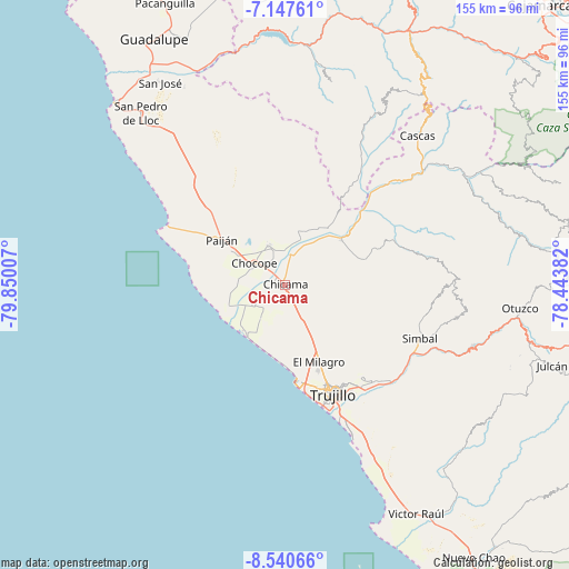
Chicama GPS coordinates[2]
7° 50' 40.992" South, 79° 8' 48.984" West
| Map corner | latitude | longitude |
|---|---|---|
| Upper-left | -7.14761°, | -79.85007° |
| Center: | -7.84472°, | -79.14694° |
| Lower-right: | -8.54066°, | -78.44382° |
| Map W x H: | 154.9×154.9 km | = 96.3×96.3mi |
| max Lat: | -0.96667° ⇑25.3% North |
| Chicama: | -7.84472° |
| min Lat: | ⇓74.7% South -18.01465° |
| min Long | Chicama | max Long |
| -81.30472° | -79.14694° | -69.04167° |
| W 8.7%⇐ | ⇒91.3% E |
Elevation
Elevation of Chicama is 131 m = 430 ft, and this is 2187.7 m = 7177 ft below average elevation for this country.
| Max E: |
5022 m = 16476 ft | 87.8% |
| Avg. | 2318.7 m = 7607 ft | |
| Chicama | 131 m = 430 ft | |
Min E: |
1 m = 3 ft | 12.2% |
See also: Peru elevation on elevation.city.
Geographical zone
Chicama is located in South Torrid zone (between Equator and Tropic of Capricorn). Distance of Equator is 872.3 km =542 mi to North.| Distance of | km | miles | from Chicama |
|---|---|---|---|
| Equator | 872.3 | 542 | to North |
| Tropic Capricorn | 1733.7 | 1077.3 | to South |
| Antarctic Circle | 6528.9 | 4056.9 | to South |
| South Pole | 9134.8 | 5676.1 | to South |


Nearby cities:
15 places around Chicama: (largest is in red/bold)
• Ascope
15.1 km =9.4 mi,  16°
16°
• Buenos Aires
34.7 km =21.6 mi,  160°
160°
• Casa Grande
12 km =7.5 mi,  338°
338°
• Chocope
10.1 km =6.3 mi,  305°
305°
• El Porvenir
31.1 km =19.3 mi,  148°
148°
• Huanchaco
26.7 km =16.6 mi,  172°
172°
• La Esperanza
28.2 km =17.5 mi, 156°
• Laredo
34.1 km =21.2 mi,  142°
142°
• Moche
39.3 km =24.4 mi, 157°
• Paiján
21.1 km =13.1 mi, 306°
• Poroto
45.7 km =28.4 mi,  113°
113°
• Santiago de Cao
16.3 km =10.1 mi,  218°
218°
• Simbal
39.5 km =24.5 mi, 111°
• Sinsicap
41.9 km =26 mi,  88°
88°
• Trujillo
32.8 km =20.4 mi, 156°
Sources, notices
• [Note1] Compared only with cities in Peru existing in our database
• [Src1] Map data: © OpenStreetMap contributors (CC-BY-SA)
• [Src2] Other city data from geonames.org with taken over terms of usage.
• [Src3] Geographical zone / Annual Mean Temperature by Robert A. Rohde @ Wikipedia
