Quinjalca geodata
Quinjalca (Amazonas) is a seat of a third-order administrative division; located in Peru in America/Lima (GMT-5) time zone. In our database, there are 305 cities with bigger population. Compared to other cities in Peru, 89.4% of cities are located further ↓South; 75.5% of cities are located further →East and 60% of cities have lower elevation than Quinjalca. Note1


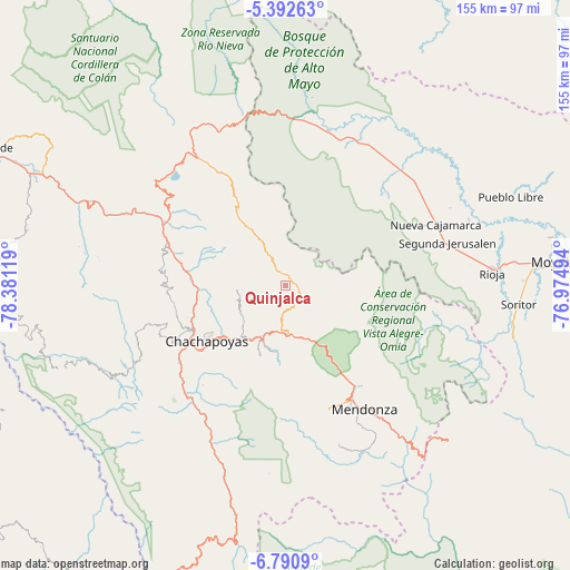
Quinjalca GPS coordinates[2]
6° 5' 31.992" South, 77° 40' 41.016" West
| Map corner | latitude | longitude |
|---|---|---|
| Upper-left | -5.39263°, | -78.38119° |
| Center: | -6.09222°, | -77.67806° |
| Lower-right: | -6.7909°, | -76.97494° |
| Map W x H: | 155.5×155.5 km | = 96.6×96.6mi |
| max Lat: | -0.96667° ⇑10.6% North |
| Quinjalca: | -6.09222° |
| min Lat: | ⇓89.4% South -18.01465° |
| min Long | Quinjalca | max Long |
| -81.30472° | -77.67806° | -69.04167° |
| W 24.5%⇐ | ⇒75.5% E |
Elevation
Elevation of Quinjalca is 3156 m = 10354 ft, and this is 837.3 m = 2747 ft above average elevation for this country.
| Max E: |
5022 m = 16476 ft | 40% |
| Quinjalca | 3156 m 10354 ft | |
| Avg. | 2318.7 m = 7607 ft | |
Min E: |
1 m = 3 ft | 60% |
See also: Peru elevation on elevation.city.
Geographical zone
Quinjalca is located in South Torrid zone (between Equator and Tropic of Capricorn). Distance of Equator is 677.4 km =420.9 mi to North.| Distance of | km | miles | from Quinjalca |
|---|---|---|---|
| Equator | 677.4 | 420.9 | to North |
| Tropic Capricorn | 1928.5 | 1198.3 | to South |
| Antarctic Circle | 6723.8 | 4178 | to South |
| South Pole | 9329.7 | 5797.2 | to South |


Nearby cities:
15 places around Quinjalca: (largest is in red/bold)
• Chachapoyas
26.2 km =16.3 mi,  233°
233°
• Cheto
18.4 km =11.4 mi,  187°
187°
• Chisquilla
24 km =14.9 mi,  345°
345°
• Churuja
31.6 km =19.6 mi,  285°
285°
• Daguas
16.5 km =10.3 mi,  204°
204°
• Granada
5.7 km =3.5 mi,  97°
97°
• Huancas
22.6 km =14 mi,  246°
246°
• Lamud
30.9 km =19.2 mi,  260°
260°
• Levanto
34.2 km =21.3 mi, 225°
• Luya
30.6 km =19 mi, 254°
• Olleros
6 km =3.7 mi,  36°
36°
• Olto
31.1 km =19.3 mi,  267°
267°
• Paclas
33.2 km =20.6 mi,  275°
275°
• San Carlos
31.5 km =19.6 mi,  296°
296°
• Soloco
20.3 km =12.6 mi, 201°
Sources, notices
• [Note1] Compared only with cities in Peru existing in our database
• [Src1] Map data: © OpenStreetMap contributors (CC-BY-SA)
• [Src2] Other city data from geonames.org with taken over terms of usage.
• [Src3] Geographical zone / Annual Mean Temperature by Robert A. Rohde @ Wikipedia
