Chimbote geodata
Chimbote (Ancash) is a seat of a third-order administrative division; located in Peru in America/Lima (GMT-5) time zone. With population of 316,966 people, there are 8 cities with bigger population in this country. Compared to other cities in Peru, 68.3% of cities are located further ↓South; 86.3% of cities are located further →East and 99% of cities have higher elevation than Chimbote. Note1


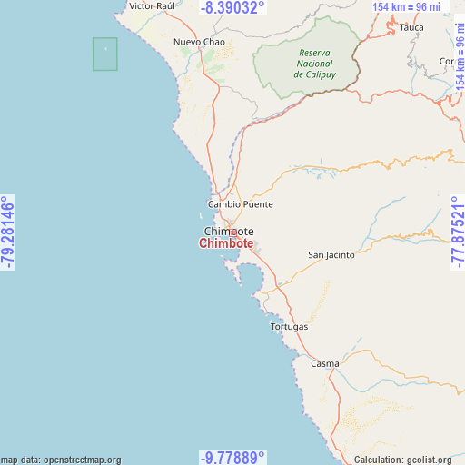
Chimbote GPS coordinates[2]
9° 5' 7.008" South, 78° 34' 41.988" West
| Map corner | latitude | longitude |
|---|---|---|
| Upper-left | -8.39032°, | -79.28146° |
| Center: | -9.08528°, | -78.57833° |
| Lower-right: | -9.77889°, | -77.87521° |
| Map W x H: | 154.4×154.4 km | = 95.9×95.9mi |
| max Lat: | -0.96667° ⇑31.7% North |
| Chimbote: | -9.08528° |
| min Lat: | ⇓68.3% South -18.01465° |
| min Long | Chimbote | max Long |
| -81.30472° | -78.57833° | -69.04167° |
| W 13.7%⇐ | ⇒86.3% E |
Elevation
Elevation of Chimbote is 9 m = 30 ft, and this is 2309.7 m = 7578 ft below average elevation for this country.
| Max E: |
5022 m = 16476 ft | 99% |
| Avg. | 2318.7 m = 7607 ft | |
| Chimbote | 9 m = 30 ft | |
Min E: |
1 m = 3 ft | 1% |
See also: Chimbote elevation on elevation.city.
Geographical zone
Chimbote is located in South Torrid zone (between Equator and Tropic of Capricorn). Distance of Equator is 1010.2 km =627.7 mi to North.| Distance of | km | miles | from Chimbote |
|---|---|---|---|
| Equator | 1010.2 | 627.7 | to North |
| Tropic Capricorn | 1595.7 | 991.5 | to South |
| Antarctic Circle | 6391 | 3971.2 | to South |
| South Pole | 8996.9 | 5590.4 | to South |


Nearby cities:
15 places around Chimbote: (largest is in red/bold)
• Buenos Aires
9.9 km =6.2 mi,  115°
115°
• Casma
52.9 km =32.9 mi,  144°
144°
• Chao
61.3 km =38.1 mi,  349°
349°
• Coishco
8 km =5 mi,  329°
329°
• Guadalupito
15.8 km =9.8 mi,  341°
341°
• Macate
64.9 km =40.3 mi,  56°
56°
• Moro
43.9 km =27.3 mi,  97°
97°
• Nepeña
26 km =16.2 mi,  111°
111°
• Pamparomas
65.6 km =40.8 mi,  88°
88°
• Puerto Casma
47.2 km =29.3 mi,  152°
152°
• Puerto Santa
13.2 km =8.2 mi, 325°
• Quillo
64.9 km =40.3 mi, 114°
• Samanco
21.6 km =13.4 mi,  155°
155°
• Santa
11.4 km =7.1 mi, 341°
• Virú
76.9 km =47.8 mi, 345°
Sources, notices
• [Note1] Compared only with cities in Peru existing in our database
• [Src1] Map data: © OpenStreetMap contributors (CC-BY-SA)
• [Src2] Other city data from geonames.org with taken over terms of usage.
• [Src3] Geographical zone / Annual Mean Temperature by Robert A. Rohde @ Wikipedia
