Puerto Santa geodata
Puerto Santa (Ancash) is a populated place; located in Peru in America/Lima (GMT-5) time zone. With population of 14,066 people, there are 115 cities with bigger population in this country. Compared to other cities in Peru, 69% of cities are located further ↓South; 87% of cities are located further →East and 99.8% of cities have higher elevation than Puerto Santa. Note1


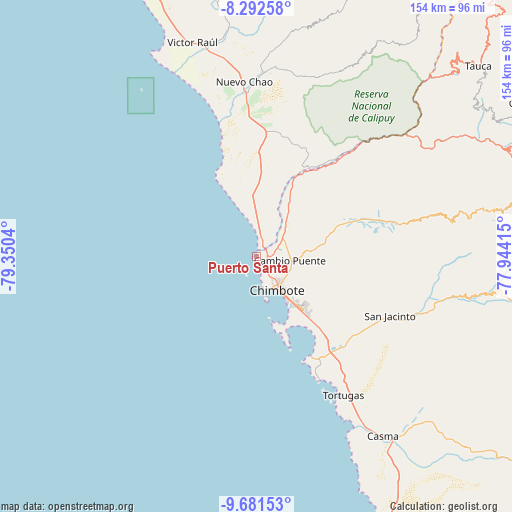
Puerto Santa GPS coordinates[2]
8° 59' 15.792" South, 78° 38' 50.172" West
| Map corner | latitude | longitude |
|---|---|---|
| Upper-left | -8.29258°, | -79.3504° |
| Center: | -8.98772°, | -78.64727° |
| Lower-right: | -9.68153°, | -77.94415° |
| Map W x H: | 154.4×154.4 km | = 95.9×95.9mi |
| max Lat: | -0.96667° ⇑31% North |
| Puerto Santa: | -8.98772° |
| min Lat: | ⇓69% South -18.01465° |
| min Long | Puerto Santa | max Long |
| -81.30472° | -78.64727° | -69.04167° |
| W 13%⇐ | ⇒87% E |
Elevation
Elevation of Puerto Santa is 5 m = 16 ft, and this is 2313.7 m = 7591 ft below average elevation for this country.
| Max E: |
5022 m = 16476 ft | 99.8% |
| Avg. | 2318.7 m = 7607 ft | |
| Puerto Santa | 5 m = 16 ft | |
Min E: |
1 m = 3 ft | 0.2% |
See also: Peru elevation on elevation.city.
Geographical zone
Puerto Santa is located in South Torrid zone (between Equator and Tropic of Capricorn). Distance of Equator is 999.3 km =620.9 mi to North.| Distance of | km | miles | from Puerto Santa |
|---|---|---|---|
| Equator | 999.3 | 620.9 | to North |
| Tropic Capricorn | 1606.6 | 998.3 | to South |
| Antarctic Circle | 6401.8 | 3977.9 | to South |
| South Pole | 9007.7 | 5597.1 | to South |


Nearby cities:
15 places around Puerto Santa: (largest is in red/bold)
• Buenos Aires
22.4 km =13.9 mi,  132°
132°
• Casma
66.1 km =41.1 mi,  144°
144°
• Chao
49.6 km =30.8 mi,  355°
355°
• Chimbote
13.2 km =8.2 mi,  145°
145°
• Coishco
5.3 km =3.3 mi, 138°
• Guadalupito
5 km =3.1 mi,  32°
32°
• Macate
66.7 km =41.4 mi,  68°
68°
• Moro
53.8 km =33.4 mi,  108°
108°
• Nepeña
37.7 km =23.4 mi,  122°
122°
• Pamparomas
73.7 km =45.8 mi,  97°
97°
• Puerto Casma
60.4 km =37.5 mi, 151°
• Quillo
76.6 km =47.6 mi, 119°
• Samanco
34.7 km =21.6 mi, 151°
• Santa
3.9 km =2.4 mi,  91°
91°
• Virú
64.7 km =40.2 mi,  349°
349°
Sources, notices
• [Note1] Compared only with cities in Peru existing in our database
• [Src1] Map data: © OpenStreetMap contributors (CC-BY-SA)
• [Src2] Other city data from geonames.org with taken over terms of usage.
• [Src3] Geographical zone / Annual Mean Temperature by Robert A. Rohde @ Wikipedia
