Paiján geodata
Paiján (La Libertad) is a populated place; located in Peru in America/Lima (GMT-5) time zone. With population of 21,128 people, there are 81 cities with bigger population in this country. Compared to other cities in Peru, 75.4% of cities are located further ↓South; 92.3% of cities are located further →East and 89.8% of cities have higher elevation than Paiján. Note1


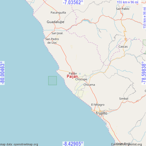
Paiján GPS coordinates[2]
7° 43' 58.476" South, 79° 18' 5.4" West
| Map corner | latitude | longitude |
|---|---|---|
| Upper-left | -7.03562°, | -80.00463° |
| Center: | -7.73291°, | -79.3015° |
| Lower-right: | -8.42905°, | -78.59838° |
| Map W x H: | 154.9×154.9 km | = 96.3×96.3mi |
| max Lat: | -0.96667° ⇑24.6% North |
| Paiján: | -7.73291° |
| min Lat: | ⇓75.4% South -18.01465° |
| min Long | Paiján | max Long |
| -81.30472° | -79.3015° | -69.04167° |
| W 7.7%⇐ | ⇒92.3% E |
Elevation
Elevation of Paiján is 93 m = 305 ft, and this is 2225.7 m = 7302 ft below average elevation for this country.
| Max E: |
5022 m = 16476 ft | 89.8% |
| Avg. | 2318.7 m = 7607 ft | |
| Paiján | 93 m = 305 ft | |
Min E: |
1 m = 3 ft | 10.2% |
See also: Peru elevation on elevation.city.
Geographical zone
Paiján is located in South Torrid zone (between Equator and Tropic of Capricorn). Distance of Equator is 859.8 km =534.3 mi to North.| Distance of | km | miles | from Paiján |
|---|---|---|---|
| Equator | 859.8 | 534.3 | to North |
| Tropic Capricorn | 1746.1 | 1085 | to South |
| Antarctic Circle | 6541.4 | 4064.6 | to South |
| South Pole | 9147.2 | 5683.8 | to South |


Nearby cities:
15 places around Paiján: (largest is in red/bold)
• Ascope
21.4 km =13.3 mi,  84°
84°
• Buenos Aires
53.5 km =33.2 mi,  147°
147°
• Casa Grande
12.7 km =7.9 mi,  95°
95°
• Chicama
21.1 km =13.1 mi,  126°
126°
• Chocope
10.9 km =6.8 mi, 126°
• El Porvenir
51.2 km =31.8 mi,  139°
139°
• Huanchaco
44 km =27.3 mi, 152°
• La Esperanza
47.6 km =29.6 mi, 143°
• Pacasmayo
47.4 km =29.5 mi,  321°
321°
• San Benito
52.5 km =32.6 mi,  50°
50°
• San Pedro de Lloc
40.5 km =25.2 mi,  326°
326°
• Santiago de Cao
26 km =16.2 mi,  164°
164°
• Tembladera
54.5 km =33.9 mi,  17°
17°
• Trinidad
51.8 km =32.2 mi,  34°
34°
• Trujillo
52 km =32.3 mi, 144°
Sources, notices
• [Note1] Compared only with cities in Peru existing in our database
• [Src1] Map data: © OpenStreetMap contributors (CC-BY-SA)
• [Src2] Other city data from geonames.org with taken over terms of usage.
• [Src3] Geographical zone / Annual Mean Temperature by Robert A. Rohde @ Wikipedia
