Pacasmayo geodata
Pacasmayo (La Libertad) is a seat of a third-order administrative division; located in Peru in America/Lima (GMT-5) time zone. With population of 29,165 people, there are 59 cities with bigger population in this country. Compared to other cities in Peru, 76.5% of cities are located further ↓South; 93.6% of cities are located further →East and 98.3% of cities have higher elevation than Pacasmayo. Note1


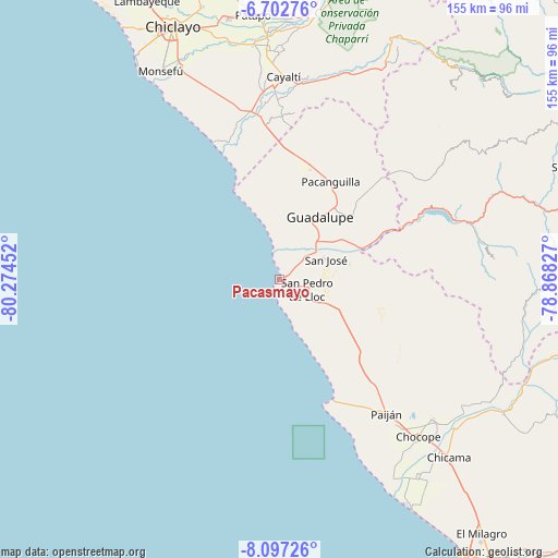
Pacasmayo GPS coordinates[2]
7° 24' 2.016" South, 79° 34' 17.004" West
| Map corner | latitude | longitude |
|---|---|---|
| Upper-left | -6.70276°, | -80.27452° |
| Center: | -7.40056°, | -79.57139° |
| Lower-right: | -8.09726°, | -78.86827° |
| Map W x H: | 155.1×155.1 km | = 96.4×96.4mi |
| max Lat: | -0.96667° ⇑23.5% North |
| Pacasmayo: | -7.40056° |
| min Lat: | ⇓76.5% South -18.01465° |
| min Long | Pacasmayo | max Long |
| -81.30472° | -79.57139° | -69.04167° |
| W 6.4%⇐ | ⇒93.6% E |
Elevation
Elevation of Pacasmayo is 12 m = 39 ft, and this is 2306.7 m = 7568 ft below average elevation for this country.
| Max E: |
5022 m = 16476 ft | 98.3% |
| Avg. | 2318.7 m = 7607 ft | |
| Pacasmayo | 12 m = 39 ft | |
Min E: |
1 m = 3 ft | 1.7% |
See also: Peru elevation on elevation.city.
Geographical zone
Pacasmayo is located in South Torrid zone (between Equator and Tropic of Capricorn). Distance of Equator is 822.9 km =511.3 mi to North.| Distance of | km | miles | from Pacasmayo |
|---|---|---|---|
| Equator | 822.9 | 511.3 | to North |
| Tropic Capricorn | 1783.1 | 1108 | to South |
| Antarctic Circle | 6578.3 | 4087.6 | to South |
| South Pole | 9184.2 | 5706.8 | to South |


Nearby cities:
15 places around Pacasmayo: (largest is in red/bold)
• Ascope
61.9 km =38.5 mi,  124°
124°
• Casa Grande
57.1 km =35.5 mi,  131°
131°
• Chepén
25.4 km =15.8 mi,  39°
39°
• Chocope
58.1 km =36.1 mi,  138°
138°
• Eten
63.6 km =39.5 mi,  329°
329°
• Guadalupe
19.4 km =12.1 mi,  30°
30°
• Mocupe
46 km =28.6 mi,  353°
353°
• Nanchoc
61 km =37.9 mi, 36°
• Pacanga
27.2 km =16.9 mi,  16°
16°
• Paiján
47.4 km =29.5 mi, 141°
• Pueblo Nuevo
24.4 km =15.2 mi,  14°
14°
• San Pedro de Lloc
8.1 km =5 mi,  113°
113°
• Saña
53.6 km =33.3 mi,  358°
358°
• Tembladera
48.8 km =30.3 mi,  72°
72°
• Trinidad
59.6 km =37 mi,  84°
84°
Sources, notices
• [Note1] Compared only with cities in Peru existing in our database
• [Src1] Map data: © OpenStreetMap contributors (CC-BY-SA)
• [Src2] Other city data from geonames.org with taken over terms of usage.
• [Src3] Geographical zone / Annual Mean Temperature by Robert A. Rohde @ Wikipedia
