Navarro geodata
Navarro (San Martín) is a seat of a third-order administrative division; located in Peru in America/Lima (GMT-5) time zone. In our database, there are 305 cities with bigger population. Compared to other cities in Peru, 87.1% of cities are located further ↓South; 50.2% of cities are located further →East and 86.1% of cities have higher elevation than Navarro. Note1


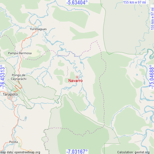
Navarro GPS coordinates[2]
6° 19' 59.988" South, 75° 45' 0" West
| Map corner | latitude | longitude |
|---|---|---|
| Upper-left | -5.63404°, | -76.45313° |
| Center: | -6.33333°, | -75.75° |
| Lower-right: | -7.03167°, | -75.04688° |
| Map W x H: | 155.4×155.4 km | = 96.6×96.6mi |
| max Lat: | -0.96667° ⇑12.9% North |
| Navarro: | -6.33333° |
| min Lat: | ⇓87.1% South -18.01465° |
| min Long | Navarro | max Long |
| -81.30472° | -75.75° | -69.04167° |
| W 49.8%⇐ | ⇒50.2% E |
Elevation
Elevation of Navarro is 160 m = 525 ft, and this is 2158.7 m = 7082 ft below average elevation for this country.
| Max E: |
5022 m = 16476 ft | 86.1% |
| Avg. | 2318.7 m = 7607 ft | |
| Navarro | 160 m = 525 ft | |
Min E: |
1 m = 3 ft | 13.9% |
See also: Peru elevation on elevation.city.
Geographical zone
Navarro is located in South Torrid zone (between Equator and Tropic of Capricorn). Distance of Equator is 704.2 km =437.6 mi to North.| Distance of | km | miles | from Navarro |
|---|---|---|---|
| Equator | 704.2 | 437.6 | to North |
| Tropic Capricorn | 1901.7 | 1181.7 | to South |
| Antarctic Circle | 6697 | 4161.3 | to South |
| South Pole | 9302.9 | 5780.6 | to South |


Nearby cities:
15 places around Navarro: (largest is in red/bold)
• Barranquita
30.4 km =18.9 mi,  284°
284°
• Buenos Aires
81.5 km =50.6 mi,  231°
231°
• Chazuta
50.3 km =31.3 mi,  238°
238°
• Cuñumbuqui
83 km =51.6 mi,  256°
256°
• Juan Guerra
69.8 km =43.4 mi,  246°
246°
• Pelejo
14.9 km =9.3 mi,  330°
330°
• Pilluana
77.5 km =48.2 mi, 230°
• San Antonio
66.4 km =41.3 mi,  266°
266°
• Sauce
65 km =40.4 mi, 232°
• Shapaja
62.9 km =39.1 mi, 244°
• Shucushuyacu
36.9 km =22.9 mi,  342°
342°
• Tarapoto
70.5 km =43.8 mi, 254°
• Tres Unidos
74.7 km =46.4 mi, 225°
• Utcurarca
69.7 km =43.3 mi, 238°
• Yurimaguas
63.2 km =39.3 mi,  319°
319°
Sources, notices
• [Note1] Compared only with cities in Peru existing in our database
• [Src1] Map data: © OpenStreetMap contributors (CC-BY-SA)
• [Src2] Other city data from geonames.org with taken over terms of usage.
• [Src3] Geographical zone / Annual Mean Temperature by Robert A. Rohde @ Wikipedia
