Yurimaguas geodata
Yurimaguas (Loreto) is a seat of a third-order administrative division; located in Peru in America/Lima (GMT-5) time zone. With population of 41,827 people, there are 44 cities with bigger population in this country. Compared to other cities in Peru, 91% of cities are located further ↓South; 53.8% of cities are located further →East and 87.3% of cities have higher elevation than Yurimaguas. Note1


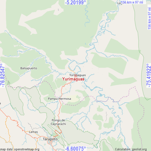
Yurimaguas GPS coordinates[2]
5° 54' 6.516" South, 76° 7' 20.424" West
| Map corner | latitude | longitude |
|---|---|---|
| Upper-left | -5.20199°, | -76.82547° |
| Center: | -5.90181°, | -76.12234° |
| Lower-right: | -6.60075°, | -75.41922° |
| Map W x H: | 155.5×155.5 km | = 96.6×96.6mi |
| max Lat: | -0.96667° ⇑9% North |
| Yurimaguas: | -5.90181° |
| min Lat: | ⇓91% South -18.01465° |
| min Long | Yurimaguas | max Long |
| -81.30472° | -76.12234° | -69.04167° |
| W 46.2%⇐ | ⇒53.8% E |
Elevation
Elevation of Yurimaguas is 143 m = 469 ft, and this is 2175.7 m = 7138 ft below average elevation for this country.
| Max E: |
5022 m = 16476 ft | 87.3% |
| Avg. | 2318.7 m = 7607 ft | |
| Yurimaguas | 143 m = 469 ft | |
Min E: |
1 m = 3 ft | 12.7% |
See also: Yurimaguas elevation on elevation.city.
Geographical zone
Yurimaguas is located in South Torrid zone (between Equator and Tropic of Capricorn). Distance of Equator is 656.2 km =407.7 mi to North.| Distance of | km | miles | from Yurimaguas |
|---|---|---|---|
| Equator | 656.2 | 407.7 | to North |
| Tropic Capricorn | 1949.7 | 1211.5 | to South |
| Antarctic Circle | 6745 | 4191.1 | to South |
| South Pole | 9350.8 | 5810.3 | to South |


Nearby cities:
15 places around Yurimaguas: (largest is in red/bold)
• Barranquita
42.2 km =26.2 mi,  163°
163°
• Chazuta
74.4 km =46.2 mi,  181°
181°
• Cuñumbuqui
78.4 km =48.7 mi,  210°
210°
• Jeberos
71 km =44.1 mi,  345°
345°
• Juan Guerra
79.1 km =49.2 mi,  196°
196°
• Lamas
73.1 km =45.4 mi,  218°
218°
• Navarro
63.2 km =39.3 mi,  139°
139°
• Pelejo
48.7 km =30.3 mi, 136°
• San Antonio
57.5 km =35.7 mi, 205°
• Santa Cruz
52.9 km =32.9 mi,  42°
42°
• Shapaja
77 km =47.8 mi,  191°
191°
• Shucushuyacu
32.7 km =20.3 mi,  112°
112°
• Tabalosos
79.6 km =49.5 mi,  231°
231°
• Tarapoto
71.9 km =44.7 mi, 201°
• Zapatero
80.9 km =50.3 mi, 210°
Sources, notices
• [Note1] Compared only with cities in Peru existing in our database
• [Src1] Map data: © OpenStreetMap contributors (CC-BY-SA)
• [Src2] Other city data from geonames.org with taken over terms of usage.
• [Src3] Geographical zone / Annual Mean Temperature by Robert A. Rohde @ Wikipedia
