Los Organos geodata
Los Organos (Piura) is a seat of a third-order administrative division; located in Peru in America/Lima (GMT-5) time zone. In our database, there are 305 cities with bigger population. Compared to other cities in Peru, 98.3% of cities are located further ↓South; 99.7% of cities are located further →East and 99.5% of cities have higher elevation than Los Organos. Note1


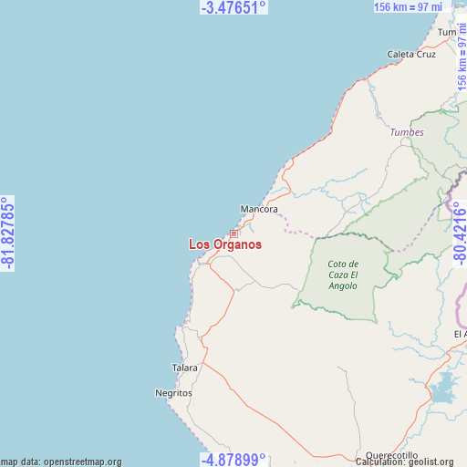
Los Organos GPS coordinates[2]
4° 10' 41.016" South, 81° 7' 28.992" West
| Map corner | latitude | longitude |
|---|---|---|
| Upper-left | -3.47651°, | -81.82785° |
| Center: | -4.17806°, | -81.12472° |
| Lower-right: | -4.87899°, | -80.4216° |
| Map W x H: | 155.9×155.9 km | = 96.9×96.9mi |
| max Lat: | -0.96667° ⇑1.7% North |
| Los Organos: | -4.17806° |
| min Lat: | ⇓98.3% South -18.01465° |
| min Long | Los Organos | max Long |
| -81.30472° | -81.12472° | -69.04167° |
| W 0.3%⇐ | ⇒99.7% E |
Elevation
Elevation of Los Organos is 7 m = 23 ft, and this is 2311.7 m = 7584 ft below average elevation for this country.
| Max E: |
5022 m = 16476 ft | 99.5% |
| Avg. | 2318.7 m = 7607 ft | |
| Los Organos | 7 m = 23 ft | |
Min E: |
1 m = 3 ft | 0.5% |
See also: Peru elevation on elevation.city.
Geographical zone
Los Organos is located in South Torrid zone (between Equator and Tropic of Capricorn). Distance of Equator is 464.6 km =288.7 mi to North.| Distance of | km | miles | from Los Organos |
|---|---|---|---|
| Equator | 464.6 | 288.7 | to North |
| Tropic Capricorn | 2141.4 | 1330.6 | to South |
| Antarctic Circle | 6936.6 | 4310.2 | to South |
| South Pole | 9542.5 | 5929.4 | to South |


Nearby cities:
15 places around Los Organos: (largest is in red/bold)
• Amotape
79.2 km =49.2 mi,  171°
171°
• Arenal
79.2 km =49.2 mi, 172°
• Cancas
32.8 km =20.4 mi,  38°
38°
• Cañaveral
58.8 km =36.5 mi,  63°
63°
• El Alto
14.4 km =8.9 mi,  225°
225°
• La Breita
27.9 km =17.3 mi,  108°
108°
• La Huaca
83.6 km =51.9 mi, 167°
• Lobitos
35.7 km =22.2 mi,  209°
209°
• Máncora
11.6 km =7.2 mi,  47°
47°
• Negritos
56.5 km =35.1 mi,  200°
200°
• Papayal
44.4 km =27.6 mi,  75°
75°
• San Jacinto
78.9 km =49 mi,  159°
159°
• Talara
47.3 km =29.4 mi, 200°
• Tamarindo
79.5 km =49.4 mi, 167°
• Zorritos
74.3 km =46.2 mi, 41°
Sources, notices
• [Note1] Compared only with cities in Peru existing in our database
• [Src1] Map data: © OpenStreetMap contributors (CC-BY-SA)
• [Src2] Other city data from geonames.org with taken over terms of usage.
• [Src3] Geographical zone / Annual Mean Temperature by Robert A. Rohde @ Wikipedia
