Cancas geodata
Cancas (Tumbes) is a seat of a third-order administrative division; located in Peru in America/Lima (GMT-5) time zone. In our database, there are 305 cities with bigger population. Compared to other cities in Peru, 98.6% of cities are located further ↓South; 99.1% of cities are located further →East and 96.3% of cities have higher elevation than Cancas. Note1
Administrative division(s):
- Level 1: Tumbes
- Level 2: Provincia de Contralmirante Villar
- Level 3: Canoas De Punta Sal


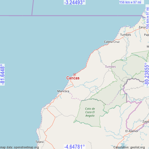
Cancas GPS coordinates[2]
3° 56' 48.012" South, 80° 56' 30.012" West
| Map corner | latitude | longitude |
|---|---|---|
| Upper-left | -3.24493°, | -81.6448° |
| Center: | -3.94667°, | -80.94167° |
| Lower-right: | -4.64781°, | -80.23855° |
| Map W x H: | 156×156 km | = 96.9×96.9mi |
| max Lat: | -0.96667° ⇑1.4% North |
| Cancas: | -3.94667° |
| min Lat: | ⇓98.6% South -18.01465° |
| min Long | Cancas | max Long |
| -81.30472° | -80.94167° | -69.04167° |
| W 0.9%⇐ | ⇒99.1% E |
Elevation
Elevation of Cancas is 22 m = 72 ft, and this is 2296.7 m = 7535 ft below average elevation for this country.
| Max E: |
5022 m = 16476 ft | 96.3% |
| Avg. | 2318.7 m = 7607 ft | |
| Cancas | 22 m = 72 ft | |
Min E: |
1 m = 3 ft | 3.7% |
See also: Peru elevation on elevation.city.
Geographical zone
Cancas is located in South Torrid zone (between Equator and Tropic of Capricorn). Distance of Equator is 438.8 km =272.7 mi to North.| Distance of | km | miles | from Cancas |
|---|---|---|---|
| Equator | 438.8 | 272.7 | to North |
| Tropic Capricorn | 2167.1 | 1346.6 | to South |
| Antarctic Circle | 6962.3 | 4326.2 | to South |
| South Pole | 9568.2 | 5945.4 | to South |


Nearby cities:
15 places around Cancas: (largest is in red/bold)
• Caleta Cruz
51.9 km =32.2 mi,  48°
48°
• Cañaveral
32.3 km =20.1 mi,  89°
89°
• El Alto
47.1 km =29.3 mi,  220°
220°
• La Breita
35 km =21.7 mi,  169°
169°
• Lobitos
68.3 km =42.4 mi,  213°
213°
• Los Organos
32.8 km =20.4 mi, 218°
• Matapalo
87.5 km =54.4 mi,  70°
70°
• Máncora
21.4 km =13.3 mi, 213°
• Negritos
88.3 km =54.9 mi, 207°
• Papayal
27 km =16.8 mi,  122°
122°
• San Jacinto
64.5 km =40.1 mi,  58°
58°
• Talara
79.1 km =49.2 mi, 207°
• Tumbes
68.8 km =42.8 mi, 52°
• Zarumilla
89.1 km =55.4 mi, 56°
• Zorritos
41.6 km =25.8 mi,  44°
44°
Sources, notices
• [Note1] Compared only with cities in Peru existing in our database
• [Src1] Map data: © OpenStreetMap contributors (CC-BY-SA)
• [Src2] Other city data from geonames.org with taken over terms of usage.
• [Src3] Geographical zone / Annual Mean Temperature by Robert A. Rohde @ Wikipedia
