Tumbes geodata
Tumbes is a seat of a first-order administrative division; located in Peru in America/Lima (GMT-5) time zone. With population of 109,223 people, there are 21 cities with bigger population in this country. Compared to other cities in Peru, 99.5% of cities are located further ↓South; 97.4% of cities are located further →East and 95.8% of cities have higher elevation than Tumbes. Note1


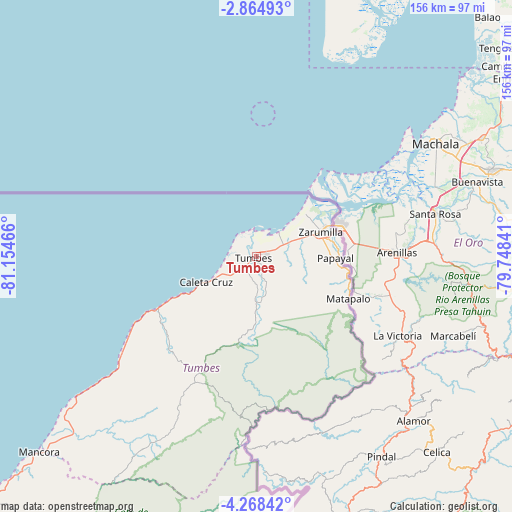
Tumbes GPS coordinates[2]
3° 34' 0.984" South, 80° 27' 5.508" West
| Map corner | latitude | longitude |
|---|---|---|
| Upper-left | -2.86493°, | -81.15466° |
| Center: | -3.56694°, | -80.45153° |
| Lower-right: | -4.26842°, | -79.74841° |
| Map W x H: | 156.1×156.1 km | = 97×97mi |
| max Lat: | -0.96667° ⇑0.5% North |
| Tumbes: | -3.56694° |
| min Lat: | ⇓99.5% South -18.01465° |
| min Long | Tumbes | max Long |
| -81.30472° | -80.45153° | -69.04167° |
| W 2.6%⇐ | ⇒97.4% E |
Elevation
Elevation of Tumbes is 25 m = 82 ft, and this is 2293.7 m = 7525 ft below average elevation for this country.
| Max E: |
5022 m = 16476 ft | 95.8% |
| Avg. | 2318.7 m = 7607 ft | |
| Tumbes | 25 m = 82 ft | |
Min E: |
1 m = 3 ft | 4.2% |
See also: Tumbes elevation on elevation.city.
Geographical zone
Tumbes is located in South Torrid zone (between Equator and Tropic of Capricorn). Distance of Equator is 396.6 km =246.4 mi to North.| Distance of | km | miles | from Tumbes |
|---|---|---|---|
| Equator | 396.6 | 246.4 | to North |
| Tropic Capricorn | 2209.3 | 1372.8 | to South |
| Antarctic Circle | 7004.6 | 4352.5 | to South |
| South Pole | 9610.5 | 5971.7 | to South |


Nearby cities:
15 places around Tumbes: (largest is in red/bold)
• Aguas Verdes
24.8 km =15.4 mi,  67°
67°
• Caleta Cruz
17.4 km =10.8 mi,  243°
243°
• Cancas
68.8 km =42.8 mi,  232°
232°
• Cañaveral
47.2 km =29.3 mi,  207°
207°
• El Alto
115.3 km =71.6 mi, 227°
• La Breita
90.6 km =56.3 mi, 212°
• Los Organos
101 km =62.8 mi, 227°
• Matapalo
30.8 km =19.1 mi,  114°
114°
• Máncora
89.4 km =55.6 mi, 227°
• Papayal
27.1 km =16.8 mi,  96°
96°
• Papayal
65 km =40.4 mi, 209°
• San Jacinto
8.4 km =5.2 mi,  176°
176°
• Suyo
116.4 km =72.3 mi,  154°
154°
• Zarumilla
21 km =13 mi, 70°
• Zorritos
28.1 km =17.5 mi, 243°
Sources, notices
• [Note1] Compared only with cities in Peru existing in our database
• [Src1] Map data: © OpenStreetMap contributors (CC-BY-SA)
• [Src2] Other city data from geonames.org with taken over terms of usage.
• [Src3] Geographical zone / Annual Mean Temperature by Robert A. Rohde @ Wikipedia
