Matapalo geodata
Matapalo (Tumbes) is a seat of a third-order administrative division; located in Peru in America/Lima (GMT-5) time zone. In our database, there are 305 cities with bigger population. Compared to other cities in Peru, 99.1% of cities are located further ↓South; 96.9% of cities are located further →East and 92% of cities have higher elevation than Matapalo. Note1


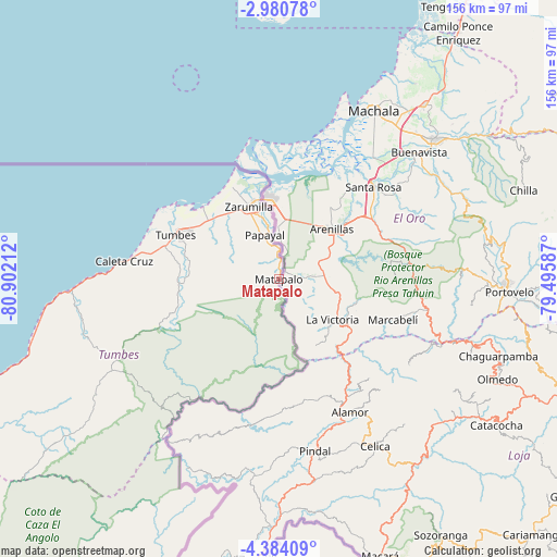
Matapalo GPS coordinates[2]
3° 40' 57.756" South, 80° 11' 56.364" West
| Map corner | latitude | longitude |
|---|---|---|
| Upper-left | -2.98078°, | -80.90212° |
| Center: | -3.68271°, | -80.19899° |
| Lower-right: | -4.38409°, | -79.49587° |
| Map W x H: | 156×156 km | = 96.9×96.9mi |
| max Lat: | -0.96667° ⇑0.9% North |
| Matapalo: | -3.68271° |
| min Lat: | ⇓99.1% South -18.01465° |
| min Long | Matapalo | max Long |
| -81.30472° | -80.19899° | -69.04167° |
| W 3.1%⇐ | ⇒96.9% E |
Elevation
Elevation of Matapalo is 64 m = 210 ft, and this is 2254.7 m = 7397 ft below average elevation for this country.
| Max E: |
5022 m = 16476 ft | 92% |
| Avg. | 2318.7 m = 7607 ft | |
| Matapalo | 64 m = 210 ft | |
Min E: |
1 m = 3 ft | 8% |
See also: Peru elevation on elevation.city.
Geographical zone
Matapalo is located in South Torrid zone (between Equator and Tropic of Capricorn). Distance of Equator is 409.5 km =254.5 mi to North.| Distance of | km | miles | from Matapalo |
|---|---|---|---|
| Equator | 409.5 | 254.5 | to North |
| Tropic Capricorn | 2196.4 | 1364.8 | to South |
| Antarctic Circle | 6991.7 | 4344.4 | to South |
| South Pole | 9597.6 | 5963.7 | to South |


Nearby cities:
15 places around Matapalo: (largest is in red/bold)
• Aguas Verdes
23 km =14.3 mi,  347°
347°
• Caleta Cruz
43.9 km =27.3 mi,  276°
276°
• Cancas
87.5 km =54.4 mi,  250°
250°
• Cañaveral
57.8 km =35.9 mi,  240°
240°
• La Breita
99.4 km =61.8 mi,  230°
230°
• Las Lomas
108.1 km =67.2 mi,  182°
182°
• Máncora
105.3 km =65.4 mi, 243°
• Paimas
108.7 km =67.5 mi,  164°
164°
• Papayal
9.6 km =6 mi, 353°
• Papayal
74.1 km =46 mi, 233°
• San Jacinto
27.9 km =17.3 mi, 279°
• Suyo
94.9 km =59 mi,  166°
166°
• Tumbes
30.8 km =19.1 mi,  294°
294°
• Zarumilla
21.6 km =13.4 mi,  337°
337°
• Zorritos
53.2 km =33.1 mi,  270°
270°
Sources, notices
• [Note1] Compared only with cities in Peru existing in our database
• [Src1] Map data: © OpenStreetMap contributors (CC-BY-SA)
• [Src2] Other city data from geonames.org with taken over terms of usage.
• [Src3] Geographical zone / Annual Mean Temperature by Robert A. Rohde @ Wikipedia
