Locumba geodata
Locumba (Tacna) is a seat of a third-order administrative division; located in Peru in America/Lima (GMT-5) time zone. In our database, there are 305 cities with bigger population. Compared to other cities in Peru, 99.1% of cities are located further ↑North; 91.1% of cities are located further ←West and 76.7% of cities have higher elevation than Locumba. Note1


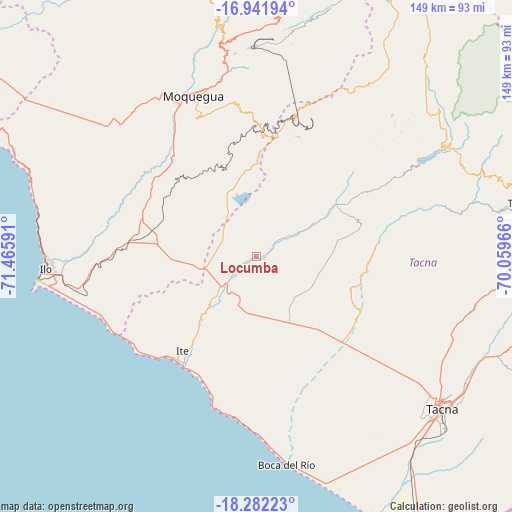
Locumba GPS coordinates[2]
17° 36' 47.988" South, 70° 45' 46.008" West
| Map corner | latitude | longitude |
|---|---|---|
| Upper-left | -16.94194°, | -71.46591° |
| Center: | -17.61333°, | -70.76278° |
| Lower-right: | -18.28223°, | -70.05966° |
| Map W x H: | 149×149 km | = 92.6×92.6mi |
| max Lat: | -0.96667° ⇑99.1% North |
| Locumba: | -17.61333° |
| min Lat: | ⇓0.9% South -18.01465° |
| min Long | Locumba | max Long |
| -81.30472° | -70.76278° | -69.04167° |
| W 91.1%⇐ | ⇒8.9% E |
Elevation
Elevation of Locumba is 598 m = 1962 ft, and this is 1720.7 m = 5645 ft below average elevation for this country.
| Max E: |
5022 m = 16476 ft | 76.7% |
| Avg. | 2318.7 m = 7607 ft | |
| Locumba | 598 m = 1962 ft | |
Min E: |
1 m = 3 ft | 23.3% |
See also: Peru elevation on elevation.city.
Geographical zone
Locumba is located in South Torrid zone (between Equator and Tropic of Capricorn). Distance of this Southern Tropic circle is 647.5 km =402.3 mi to South.| Distance of | km | miles | from Locumba |
|---|---|---|---|
| Equator | 1958.4 | 1216.9 | to North |
| Tropic Capricorn | 647.5 | 402.3 | to South |
| Antarctic Circle | 5442.8 | 3382 | to South |
| South Pole | 8048.6 | 5001.2 | to South |


Nearby cities:
15 places around Locumba: (largest is in red/bold)
• Cairani
55.8 km =34.7 mi,  49°
49°
• Camilaca
56 km =34.8 mi, 46°
• Chipispaya
59.3 km =36.8 mi,  77°
77°
• Curibaya
52.1 km =32.4 mi,  60°
60°
• El Algarrobal
53.5 km =33.2 mi,  268°
268°
• Huanuara
57.4 km =35.7 mi, 54°
• Ilabaya
34 km =21.1 mi, 51°
• Ilo
61.3 km =38.1 mi, 268°
• Las Yaras
35 km =21.7 mi,  142°
142°
• Moquegua
49.7 km =30.9 mi,  338°
338°
• Pueblo Nuevo
61 km =37.9 mi, 269°
• Sama Grande
34.7 km =21.6 mi,  125°
125°
• Samegua
50.4 km =31.3 mi, 343°
• Torata
60.3 km =37.5 mi,  351°
351°
• Totoral
48.1 km =29.9 mi, 61°
Sources, notices
• [Note1] Compared only with cities in Peru existing in our database
• [Src1] Map data: © OpenStreetMap contributors (CC-BY-SA)
• [Src2] Other city data from geonames.org with taken over terms of usage.
• [Src3] Geographical zone / Annual Mean Temperature by Robert A. Rohde @ Wikipedia
