Samegua geodata
Samegua (Moquegua) is a seat of a third-order administrative division; located in Peru in America/Lima (GMT-5) time zone. In our database, there are 305 cities with bigger population. Compared to other cities in Peru, 97.7% of cities are located further ↑North; 90.4% of cities are located further ←West and 69.2% of cities have higher elevation than Samegua. Note1


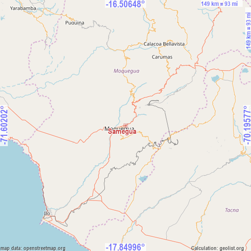
Samegua GPS coordinates[2]
17° 10' 45.984" South, 70° 53' 56.004" West
| Map corner | latitude | longitude |
|---|---|---|
| Upper-left | -16.50648°, | -71.60202° |
| Center: | -17.17944°, | -70.89889° |
| Lower-right: | -17.84996°, | -70.19577° |
| Map W x H: | 149.4×149.4 km | = 92.8×92.8mi |
| max Lat: | -0.96667° ⇑97.7% North |
| Samegua: | -17.17944° |
| min Lat: | ⇓2.3% South -18.01465° |
| min Long | Samegua | max Long |
| -81.30472° | -70.89889° | -69.04167° |
| W 90.4%⇐ | ⇒9.6% E |
Elevation
Elevation of Samegua is 1576 m = 5171 ft, and this is 742.7 m = 2437 ft below average elevation for this country.
| Max E: |
5022 m = 16476 ft | 69.2% |
| Avg. | 2318.7 m = 7607 ft | |
| Samegua | 1576 m = 5171 ft | |
Min E: |
1 m = 3 ft | 30.8% |
See also: Peru elevation on elevation.city.
Geographical zone
Samegua is located in South Torrid zone (between Equator and Tropic of Capricorn). Distance of this Southern Tropic circle is 695.7 km =432.3 mi to South.| Distance of | km | miles | from Samegua |
|---|---|---|---|
| Equator | 1910.2 | 1186.9 | to North |
| Tropic Capricorn | 695.7 | 432.3 | to South |
| Antarctic Circle | 5491 | 3411.9 | to South |
| South Pole | 8096.9 | 5031.2 | to South |


Nearby cities:
15 places around Samegua: (largest is in red/bold)
• Cairani
58.1 km =36.1 mi,  101°
101°
• Calacoa
52.2 km =32.4 mi,  23°
23°
• Camilaca
56.2 km =34.9 mi, 100°
• Carumas
44.7 km =27.8 mi,  25°
25°
• Coalaque
60.2 km =37.4 mi,  347°
347°
• Cuchumbaya
53 km =32.9 mi, 25°
• Ilabaya
48.9 km =30.4 mi,  123°
123°
• La Capilla
55.6 km =34.5 mi,  327°
327°
• Locumba
50.4 km =31.3 mi,  163°
163°
• Moquegua
4.4 km =2.7 mi,  241°
241°
• Omate
55.9 km =34.7 mi, 350°
• Pujocucho
58.1 km =36.1 mi,  87°
87°
• Quinistaquillas
47.8 km =29.7 mi,  1°
1°
• Torata
12.8 km =8 mi, 27°
• Totoral
62.1 km =38.6 mi,  113°
113°
Sources, notices
• [Note1] Compared only with cities in Peru existing in our database
• [Src1] Map data: © OpenStreetMap contributors (CC-BY-SA)
• [Src2] Other city data from geonames.org with taken over terms of usage.
• [Src3] Geographical zone / Annual Mean Temperature by Robert A. Rohde @ Wikipedia
