San Ramón geodata
San Ramón (Junin) is a populated place; located in Peru in America/Lima (GMT-5) time zone. With population of 14,708 people, there are 111 cities with bigger population in this country. Compared to other cities in Peru, 54.8% of cities are located further ↓South; 54.5% of cities are located further ←West and 74.1% of cities have higher elevation than San Ramón. Note1


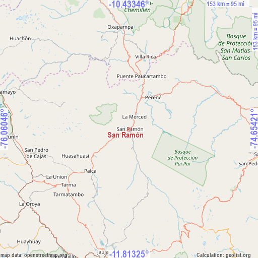
San Ramón GPS coordinates[2]
11° 7' 27.012" South, 75° 21' 26.388" West
| Map corner | latitude | longitude |
|---|---|---|
| Upper-left | -10.43346°, | -76.06046° |
| Center: | -11.12417°, | -75.35733° |
| Lower-right: | -11.81325°, | -74.65421° |
| Map W x H: | 153.4×153.4 km | = 95.3×95.3mi |
| max Lat: | -0.96667° ⇑45.2% North |
| San Ramón: | -11.12417° |
| min Lat: | ⇓54.8% South -18.01465° |
| min Long | San Ramón | max Long |
| -81.30472° | -75.35733° | -69.04167° |
| W 54.5%⇐ | ⇒45.5% E |
Elevation
Elevation of San Ramón is 832 m = 2730 ft, and this is 1486.7 m = 4878 ft below average elevation for this country.
| Max E: |
5022 m = 16476 ft | 74.1% |
| Avg. | 2318.7 m = 7607 ft | |
| San Ramón | 832 m = 2730 ft | |
Min E: |
1 m = 3 ft | 25.9% |
See also: Peru elevation on elevation.city.
Geographical zone
San Ramón is located in South Torrid zone (between Equator and Tropic of Capricorn). Distance of Equator is 1236.9 km =768.6 mi to North.| Distance of | km | miles | from San Ramón |
|---|---|---|---|
| Equator | 1236.9 | 768.6 | to North |
| Tropic Capricorn | 1369 | 850.7 | to South |
| Antarctic Circle | 6164.3 | 3830.3 | to South |
| South Pole | 8770.2 | 5449.5 | to South |


Nearby cities:
15 places around San Ramón: (largest is in red/bold)
• Acobamba
41.8 km =26 mi,  232°
232°
• Bajo Pichanaqui
57.1 km =35.5 mi,  67°
67°
• Chontabamba
61.7 km =38.3 mi,  347°
347°
• Huasahuasi
35.3 km =21.9 mi,  243°
243°
• La Merced
7.4 km =4.6 mi,  19°
19°
• Leticia
51.7 km =32.1 mi, 236°
• Mucllo
61.9 km =38.5 mi,  152°
152°
• Oxapampa
61 km =37.9 mi,  355°
355°
• Palca
33.8 km =21 mi,  223°
223°
• Palcamayo
49.2 km =30.6 mi,  247°
247°
• Perené
24.7 km =15.3 mi,  36°
36°
• San Pedro de Cajas
56.7 km =35.2 mi,  255°
255°
• Tapo
37.2 km =23.1 mi, 217°
• Tarma
48.9 km =30.4 mi, 227°
• Villa Rica
43.8 km =27.2 mi,  12°
12°
Sources, notices
• [Note1] Compared only with cities in Peru existing in our database
• [Src1] Map data: © OpenStreetMap contributors (CC-BY-SA)
• [Src2] Other city data from geonames.org with taken over terms of usage.
• [Src3] Geographical zone / Annual Mean Temperature by Robert A. Rohde @ Wikipedia
