Paccho geodata
Paccho (Lima region) is a seat of a third-order administrative division; located in Peru in America/Lima (GMT-5) time zone. In our database, there are 305 cities with bigger population. Compared to other cities in Peru, 55.7% of cities are located further ↓South; 66.4% of cities are located further →East and 65% of cities have lower elevation than Paccho. Note1


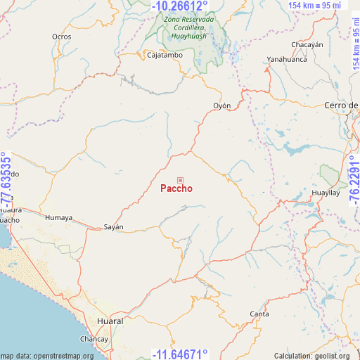
Paccho GPS coordinates[2]
10° 57' 25.992" South, 76° 55' 55.992" West
| Map corner | latitude | longitude |
|---|---|---|
| Upper-left | -10.26612°, | -77.63535° |
| Center: | -10.95722°, | -76.93222° |
| Lower-right: | -11.64671°, | -76.2291° |
| Map W x H: | 153.5×153.5 km | = 95.4×95.4mi |
| max Lat: | -0.96667° ⇑44.3% North |
| Paccho: | -10.95722° |
| min Lat: | ⇓55.7% South -18.01465° |
| min Long | Paccho | max Long |
| -81.30472° | -76.93222° | -69.04167° |
| W 33.6%⇐ | ⇒66.4% E |
Elevation
Elevation of Paccho is 3259 m = 10692 ft, and this is 940.3 m = 3085 ft above average elevation for this country.
| Max E: |
5022 m = 16476 ft | 35% |
| Paccho | 3259 m 10692 ft | |
| Avg. | 2318.7 m = 7607 ft | |
Min E: |
1 m = 3 ft | 65% |
See also: Peru elevation on elevation.city.
Geographical zone
Paccho is located in South Torrid zone (between Equator and Tropic of Capricorn). Distance of Equator is 1218.3 km =757 mi to North.| Distance of | km | miles | from Paccho |
|---|---|---|---|
| Equator | 1218.3 | 757 | to North |
| Tropic Capricorn | 1387.6 | 862.2 | to South |
| Antarctic Circle | 6182.8 | 3841.8 | to South |
| South Pole | 8788.7 | 5461 | to South |


Nearby cities:
15 places around Paccho: (largest is in red/bold)
• Acos
37.2 km =23.1 mi,  160°
160°
• Ambar
44.2 km =27.5 mi,  304°
304°
• Andajes
18.5 km =11.5 mi,  7°
7°
• Carac
30.9 km =19.2 mi,  147°
147°
• Caujul
17.6 km =10.9 mi,  343°
343°
• Gorgor
43 km =26.7 mi,  345°
345°
• Ihuari
25.9 km =16.1 mi,  184°
184°
• Jucul
20.5 km =12.7 mi,  87°
87°
• Lampian
32.8 km =20.4 mi, 162°
• Maray
11 km =6.8 mi,  77°
77°
• Oyón
36.6 km =22.7 mi,  28°
28°
• Pacaraos
40.2 km =25 mi,  129°
129°
• Pirca
43.1 km =26.8 mi,  135°
135°
• Santa Cruz
11.4 km =7.1 mi, 178°
• Sayán
34.7 km =21.6 mi,  235°
235°
Sources, notices
• [Note1] Compared only with cities in Peru existing in our database
• [Src1] Map data: © OpenStreetMap contributors (CC-BY-SA)
• [Src2] Other city data from geonames.org with taken over terms of usage.
• [Src3] Geographical zone / Annual Mean Temperature by Robert A. Rohde @ Wikipedia
