Lampian geodata
Lampian (Lima region) is a seat of a third-order administrative division; located in Peru in America/Lima (GMT-5) time zone. In our database, there are 305 cities with bigger population. Compared to other cities in Peru, 54.1% of cities are located further ↓South; 65.7% of cities are located further →East and 60.2% of cities have higher elevation than Lampian. Note1


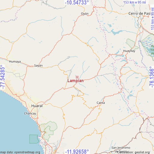
Lampian GPS coordinates[2]
11° 14' 16.008" South, 76° 50' 22.992" West
| Map corner | latitude | longitude |
|---|---|---|
| Upper-left | -10.54733°, | -77.54285° |
| Center: | -11.23778°, | -76.83972° |
| Lower-right: | -11.92658°, | -76.1366° |
| Map W x H: | 153.4×153.4 km | = 95.3×95.3mi |
| max Lat: | -0.96667° ⇑45.9% North |
| Lampian: | -11.23778° |
| min Lat: | ⇓54.1% South -18.01465° |
| min Long | Lampian | max Long |
| -81.30472° | -76.83972° | -69.04167° |
| W 34.3%⇐ | ⇒65.7% E |
Elevation
Elevation of Lampian is 2433 m = 7982 ft, and this is 114.3 m = 375 ft above average elevation for this country.
| Max E: |
5022 m = 16476 ft | 60.2% |
| Lampian | 2433 m 7982 ft | |
| Avg. | 2318.7 m = 7607 ft | |
Min E: |
1 m = 3 ft | 39.8% |
See also: Peru elevation on elevation.city.
Geographical zone
Lampian is located in South Torrid zone (between Equator and Tropic of Capricorn). Distance of Equator is 1249.5 km =776.4 mi to North.| Distance of | km | miles | from Lampian |
|---|---|---|---|
| Equator | 1249.5 | 776.4 | to North |
| Tropic Capricorn | 1356.4 | 842.8 | to South |
| Antarctic Circle | 6151.7 | 3822.5 | to South |
| South Pole | 8757.5 | 5441.7 | to South |


Nearby cities:
15 places around Lampian: (largest is in red/bold)
• Acos
4.5 km =2.8 mi,  152°
152°
• Canta
34.7 km =21.6 mi,  137°
137°
• Carac
8.2 km =5.1 mi,  51°
51°
• Huamantanga
30.7 km =19.1 mi,  161°
161°
• Huaros
34.2 km =21.3 mi,  123°
123°
• Ihuari
13.3 km =8.3 mi,  293°
293°
• Jucul
33.8 km =21 mi,  17°
17°
• Maray
33.6 km =20.9 mi,  1°
1°
• Pacaraos
21.7 km =13.5 mi,  74°
74°
• Paccho
32.8 km =20.4 mi,  342°
342°
• Pirca
20.1 km =12.5 mi,  88°
88°
• San Buenaventura
34 km =21.1 mi, 145°
• Santa Cruz
22.1 km =13.7 mi,  333°
333°
• Sayán
40.4 km =25.1 mi, 286°
• Sumbilca
19 km =11.8 mi,  173°
173°
Sources, notices
• [Note1] Compared only with cities in Peru existing in our database
• [Src1] Map data: © OpenStreetMap contributors (CC-BY-SA)
• [Src2] Other city data from geonames.org with taken over terms of usage.
• [Src3] Geographical zone / Annual Mean Temperature by Robert A. Rohde @ Wikipedia
