Andajes geodata
Andajes (Lima region) is a seat of a third-order administrative division; located in Peru in America/Lima (GMT-5) time zone. In our database, there are 305 cities with bigger population. Compared to other cities in Peru, 56.5% of cities are located further ↓South; 66.1% of cities are located further →East and 78% of cities have lower elevation than Andajes. Note1


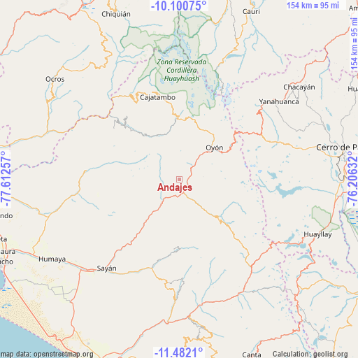
Andajes GPS coordinates[2]
10° 47' 31.992" South, 76° 54' 33.984" West
| Map corner | latitude | longitude |
|---|---|---|
| Upper-left | -10.10075°, | -77.61257° |
| Center: | -10.79222°, | -76.90944° |
| Lower-right: | -11.4821°, | -76.20632° |
| Map W x H: | 153.6×153.6 km | = 95.4×95.4mi |
| max Lat: | -0.96667° ⇑43.5% North |
| Andajes: | -10.79222° |
| min Lat: | ⇓56.5% South -18.01465° |
| min Long | Andajes | max Long |
| -81.30472° | -76.90944° | -69.04167° |
| W 33.9%⇐ | ⇒66.1% E |
Elevation
Elevation of Andajes is 3485 m = 11434 ft, and this is 1166.3 m = 3826 ft above average elevation for this country.
| Max E: |
5022 m = 16476 ft | 22% |
| Andajes | 3485 m 11434 ft | |
| Avg. | 2318.7 m = 7607 ft | |
Min E: |
1 m = 3 ft | 78% |
See also: Peru elevation on elevation.city.
Geographical zone
Andajes is located in South Torrid zone (between Equator and Tropic of Capricorn). Distance of Equator is 1200 km =745.6 mi to North.| Distance of | km | miles | from Andajes |
|---|---|---|---|
| Equator | 1200 | 745.6 | to North |
| Tropic Capricorn | 1405.9 | 873.6 | to South |
| Antarctic Circle | 6201.2 | 3853.2 | to South |
| South Pole | 8807.1 | 5472.5 | to South |


Nearby cities:
15 places around Andajes: (largest is in red/bold)
• Aco
48.9 km =30.4 mi,  312°
312°
• Ambar
39.6 km =24.6 mi,  279°
279°
• Carac
46.6 km =29 mi,  162°
162°
• Caujul
7.7 km =4.8 mi,  259°
259°
• Copa
48.6 km =30.2 mi,  337°
337°
• Gorgor
26.9 km =16.7 mi,  329°
329°
• Ihuari
44.4 km =27.6 mi,  185°
185°
• Jucul
25 km =15.5 mi,  134°
134°
• Lampian
50.1 km =31.1 mi,  171°
171°
• Mangas
51 km =31.7 mi, 335°
• Maray
17.9 km =11.1 mi,  152°
152°
• Oyón
20.4 km =12.7 mi,  47°
47°
• Paccho
18.5 km =11.5 mi, 187°
• Santa Cruz
29.9 km =18.6 mi,  184°
184°
• Sayán
49.1 km =30.5 mi,  219°
219°
Sources, notices
• [Note1] Compared only with cities in Peru existing in our database
• [Src1] Map data: © OpenStreetMap contributors (CC-BY-SA)
• [Src2] Other city data from geonames.org with taken over terms of usage.
• [Src3] Geographical zone / Annual Mean Temperature by Robert A. Rohde @ Wikipedia
