Canta geodata
Canta (Lima region) is a seat of a third-order administrative division; located in Peru in America/Lima (GMT-5) time zone. In our database, there are 305 cities with bigger population. Compared to other cities in Peru, 52.6% of cities are located further ↓South; 60.8% of cities are located further →East and 50.3% of cities have higher elevation than Canta. Note1


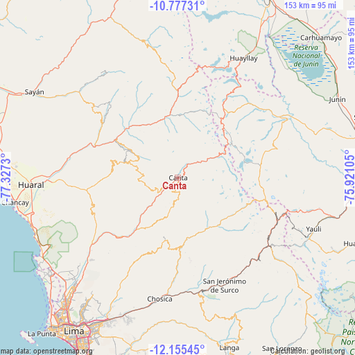
Canta GPS coordinates[2]
11° 28' 1.992" South, 76° 37' 27.012" West
| Map corner | latitude | longitude |
|---|---|---|
| Upper-left | -10.77731°, | -77.3273° |
| Center: | -11.46722°, | -76.62417° |
| Lower-right: | -12.15545°, | -75.92105° |
| Map W x H: | 153.2×153.2 km | = 95.2×95.2mi |
| max Lat: | -0.96667° ⇑47.4% North |
| Canta: | -11.46722° |
| min Lat: | ⇓52.6% South -18.01465° |
| min Long | Canta | max Long |
| -81.30472° | -76.62417° | -69.04167° |
| W 39.2%⇐ | ⇒60.8% E |
Elevation
Elevation of Canta is 2836 m = 9304 ft, and this is 517.3 m = 1697 ft above average elevation for this country.
| Max E: |
5022 m = 16476 ft | 50.3% |
| Canta | 2836 m 9304 ft | |
| Avg. | 2318.7 m = 7607 ft | |
Min E: |
1 m = 3 ft | 49.7% |
See also: Peru elevation on elevation.city.
Geographical zone
Canta is located in South Torrid zone (between Equator and Tropic of Capricorn). Distance of Equator is 1275 km =792.2 mi to North.| Distance of | km | miles | from Canta |
|---|---|---|---|
| Equator | 1275 | 792.2 | to North |
| Tropic Capricorn | 1330.9 | 827 | to South |
| Antarctic Circle | 6126.1 | 3806.6 | to South |
| South Pole | 8732 | 5425.8 | to South |


Nearby cities:
15 places around Canta: (largest is in red/bold)
• Acos
30.4 km =18.9 mi,  315°
315°
• Arahuay
17.9 km =11.1 mi,  195°
195°
• Carampoma
24.6 km =15.3 mi,  150°
150°
• Huamantanga
14 km =8.7 mi,  255°
255°
• Huanza
24.8 km =15.4 mi, 147°
• Huaros
8.5 km =5.3 mi,  37°
37°
• Lachaqui
9.6 km =6 mi,  179°
179°
• Lampian
34.7 km =21.6 mi, 317°
• Laraos
23.8 km =14.8 mi,  157°
157°
• Marcapomacocha
32.1 km =19.9 mi,  77°
77°
• Pacaraos
31.4 km =19.5 mi,  355°
355°
• Pirca
26.1 km =16.2 mi,  352°
352°
• San Buenaventura
4.8 km =3 mi,  239°
239°
• Sumbilca
22.4 km =13.9 mi,  287°
287°
• Yangas
35 km =21.7 mi,  223°
223°
Sources, notices
• [Note1] Compared only with cities in Peru existing in our database
• [Src1] Map data: © OpenStreetMap contributors (CC-BY-SA)
• [Src2] Other city data from geonames.org with taken over terms of usage.
• [Src3] Geographical zone / Annual Mean Temperature by Robert A. Rohde @ Wikipedia
