Huamantanga geodata
Huamantanga (Lima region) is a seat of a third-order administrative division; located in Peru in America/Lima (GMT-5) time zone. In our database, there are 305 cities with bigger population. Compared to other cities in Peru, 52.3% of cities are located further ↓South; 63.5% of cities are located further →East and 72.6% of cities have lower elevation than Huamantanga. Note1


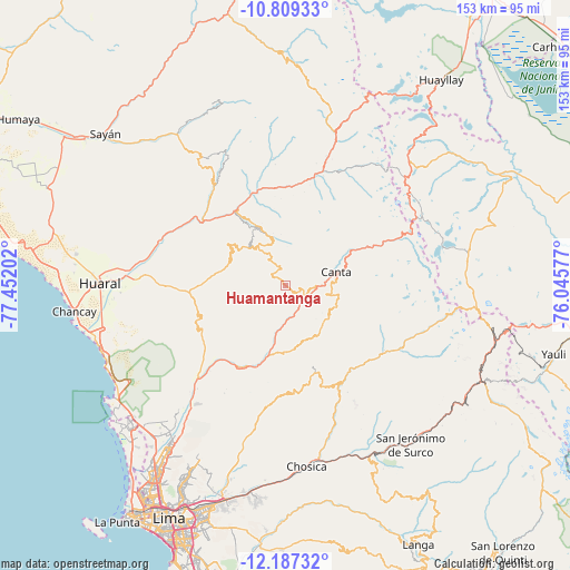
Huamantanga GPS coordinates[2]
11° 29' 57.012" South, 76° 44' 56.004" West
| Map corner | latitude | longitude |
|---|---|---|
| Upper-left | -10.80933°, | -77.45202° |
| Center: | -11.49917°, | -76.74889° |
| Lower-right: | -12.18732°, | -76.04577° |
| Map W x H: | 153.2×153.2 km | = 95.2×95.2mi |
| max Lat: | -0.96667° ⇑47.7% North |
| Huamantanga: | -11.49917° |
| min Lat: | ⇓52.3% South -18.01465° |
| min Long | Huamantanga | max Long |
| -81.30472° | -76.74889° | -69.04167° |
| W 36.5%⇐ | ⇒63.5% E |
Elevation
Elevation of Huamantanga is 3389 m = 11119 ft, and this is 1070.3 m = 3511 ft above average elevation for this country.
| Max E: |
5022 m = 16476 ft | 27.4% |
| Huamantanga | 3389 m 11119 ft | |
| Avg. | 2318.7 m = 7607 ft | |
Min E: |
1 m = 3 ft | 72.6% |
See also: Peru elevation on elevation.city.
Geographical zone
Huamantanga is located in South Torrid zone (between Equator and Tropic of Capricorn). Distance of Equator is 1278.6 km =794.5 mi to North.| Distance of | km | miles | from Huamantanga |
|---|---|---|---|
| Equator | 1278.6 | 794.5 | to North |
| Tropic Capricorn | 1327.3 | 824.7 | to South |
| Antarctic Circle | 6122.6 | 3804.4 | to South |
| South Pole | 8728.5 | 5423.6 | to South |


Nearby cities:
15 places around Huamantanga: (largest is in red/bold)
• Acos
26.3 km =16.3 mi,  342°
342°
• Arahuay
16.2 km =10.1 mi,  147°
147°
• Canta
14 km =8.7 mi,  75°
75°
• Carac
34.3 km =21.3 mi,  354°
354°
• Carampoma
31.2 km =19.4 mi,  125°
125°
• Huanza
32 km =19.9 mi,  123°
123°
• Huaros
21.4 km =13.3 mi,  61°
61°
• Lachaqui
14.9 km =9.3 mi,  113°
113°
• Lampian
30.7 km =19.1 mi, 341°
• Laraos
29.3 km =18.2 mi, 128°
• Pacaraos
36.5 km =22.7 mi,  17°
17°
• Pirca
31.1 km =19.3 mi, 19°
• San Buenaventura
9.5 km =5.9 mi, 83°
• Sumbilca
12.8 km =8 mi,  322°
322°
• Yangas
24.2 km =15 mi,  205°
205°
Sources, notices
• [Note1] Compared only with cities in Peru existing in our database
• [Src1] Map data: © OpenStreetMap contributors (CC-BY-SA)
• [Src2] Other city data from geonames.org with taken over terms of usage.
• [Src3] Geographical zone / Annual Mean Temperature by Robert A. Rohde @ Wikipedia
