Veruela geodata
Veruela (Caraga) is a populated place; located in Philippines in Asia/Manila (GMT+8) time zone. With population of 18,114 people, there are 391 cities with bigger population in this country. Compared to other cities in Philippines, 81.8% of cities are located further ↑North; 97.4% of cities are located further ←West and 58.1% of cities have lower elevation than Veruela. Note1


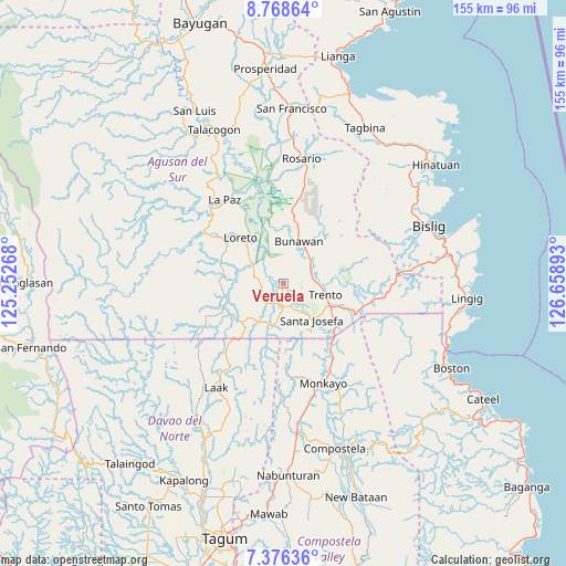
Veruela GPS coordinates[2]
8° 4' 23.16" North, 125° 57' 20.88" East
| Map corner | latitude | longitude |
|---|---|---|
| Upper-left | 8.76864°, | 125.25268° |
| Center: | 8.0731°, | 125.9558° |
| Lower-right: | 7.37636°, | 126.65893° |
| Map W x H: | 154.8×154.8 km | = 96.2×96.2mi |
| max Lat: | 20.78733° ⇑81.8% North |
| Veruela: | 8.0731° |
| min Lat: | ⇓18.2% South 4.65442° |
| min Long | Veruela | max Long |
| 117.04868° | 125.9558° | 126.58417° |
| W 97.4%⇐ | ⇒2.6% E |
Elevation
Elevation of Veruela is 31 m = 102 ft, and this is 56.9 m = 187 ft below average elevation for this country.
| Max E: |
2262 m = 7421 ft | 41.9% |
| Avg. | 87.9 m = 288 ft | |
| Veruela | 31 m = 102 ft | |
Min E: |
-2 m = -7 ft | 58.1% |
See also: Philippines elevation on elevation.city.
Geographical zone
Veruela is located in North Torrid zone (between Equator and Tropic of Cancer). Distance of Equator is 897.6 km =557.7 mi to South.| Distance of | km | miles | from Veruela |
|---|---|---|---|
| North Pole | 9109.4 | 5660.3 | to North |
| Arctic Circle | 6503.5 | 4041.1 | to North |
| Tropic Cancer | 1708.3 | 1061.5 | to North |
| Equator | 897.6 | 557.7 | to South |


Nearby cities:
15 places around Veruela: (largest is in red/bold)
• Basa
11.9 km =7.4 mi,  90°
90°
• Baylo
26.6 km =16.5 mi,  155°
155°
• Bunawan
11.2 km =7 mi,  20°
20°
• Cuevas
16.4 km =10.2 mi,  111°
111°
• La Paz
27.9 km =17.3 mi,  321°
321°
• Libertad
8.7 km =5.4 mi,  63°
63°
• Loreto
17 km =10.6 mi, 318°
• Monkayo
30.7 km =19.1 mi, 159°
• Pasian
20.3 km =12.6 mi,  142°
142°
• Salvacion
20.3 km =12.6 mi, 113°
• Santa Josefa
12.2 km =7.6 mi, 138°
• Santa Maria
23.2 km =14.4 mi,  100°
100°
• Santo Tomas
20.9 km =13 mi,  306°
306°
• Sinubong
2.8 km =1.7 mi,  259°
259°
• Trento
12.3 km =7.6 mi, 104°
Sources, notices
• [Note1] Compared only with cities in Philippines existing in our database
• [Src1] Map data: © OpenStreetMap contributors (CC-BY-SA)
• [Src2] Other city data from geonames.org with taken over terms of usage.
• [Src3] Geographical zone / Annual Mean Temperature by Robert A. Rohde @ Wikipedia
