Monkayo geodata
Monkayo (Davao) is a seat of a third-order administrative division; located in Philippines in Asia/Manila (GMT+8) time zone. With population of 51,393 people, there are 173 cities with bigger population in this country. Compared to other cities in Philippines, 84.1% of cities are located further ↑North; 98.1% of cities are located further ←West and 73.1% of cities have lower elevation than Monkayo. Note1


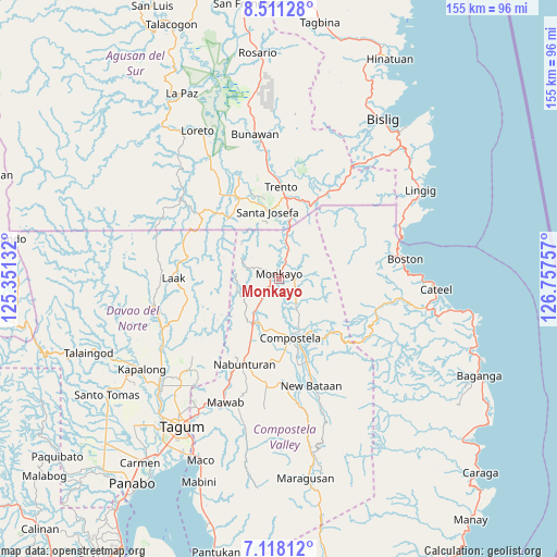
Monkayo GPS coordinates[2]
7° 48' 55.008" North, 126° 3' 15.984" East
| Map corner | latitude | longitude |
|---|---|---|
| Upper-left | 8.51128°, | 125.35132° |
| Center: | 7.81528°, | 126.05444° |
| Lower-right: | 7.11812°, | 126.75757° |
| Map W x H: | 154.9×154.9 km | = 96.3×96.3mi |
| max Lat: | 20.78733° ⇑84.1% North |
| Monkayo: | 7.81528° |
| min Lat: | ⇓15.9% South 4.65442° |
| min Long | Monkayo | max Long |
| 117.04868° | 126.05444° | 126.58417° |
| W 98.1%⇐ | ⇒1.9% E |
Elevation
Elevation of Monkayo is 61 m = 200 ft, and this is 26.9 m = 88 ft below average elevation for this country.
| Max E: |
2262 m = 7421 ft | 26.9% |
| Avg. | 87.9 m = 288 ft | |
| Monkayo | 61 m = 200 ft | |
Min E: |
-2 m = -7 ft | 73.1% |
See also: Monkayo elevation on elevation.city.
Geographical zone
Monkayo is located in North Torrid zone (between Equator and Tropic of Cancer). Distance of Equator is 869 km =540 mi to South.| Distance of | km | miles | from Monkayo |
|---|---|---|---|
| North Pole | 9138.1 | 5678.2 | to North |
| Arctic Circle | 6532.2 | 4058.9 | to North |
| Tropic Cancer | 1736.9 | 1079.3 | to North |
| Equator | 869 | 540 | to South |


Nearby cities:
15 places around Monkayo: (largest is in red/bold)
• Babag
9.3 km =5.8 mi,  168°
168°
• Bantacan
24.9 km =15.5 mi,  160°
160°
• Baylo
4.4 km =2.7 mi,  1°
1°
• Cabinuangan
14.9 km =9.3 mi,  189°
189°
• Compostela
16.3 km =10.1 mi, 166°
• Cuevas
23.1 km =14.4 mi,  10°
10°
• Gabi
21.9 km =13.6 mi, 169°
• Linoan
22.8 km =14.2 mi,  202°
202°
• Montevista
15.4 km =9.6 mi,  208°
208°
• Nabunturan
25 km =15.5 mi, 202°
• Pasian
12.6 km =7.8 mi, 6°
• Salvacion
21.9 km =13.6 mi,  20°
20°
• Santa Josefa
19.7 km =12.2 mi,  352°
352°
• Tapia
8.3 km =5.2 mi, 214°
• Trento
25.7 km =16 mi, 2°
Sources, notices
• [Note1] Compared only with cities in Philippines existing in our database
• [Src1] Map data: © OpenStreetMap contributors (CC-BY-SA)
• [Src2] Other city data from geonames.org with taken over terms of usage.
• [Src3] Geographical zone / Annual Mean Temperature by Robert A. Rohde @ Wikipedia
