Bunawan geodata
Bunawan (Caraga) is a seat of a third-order administrative division; located in Philippines in Asia/Manila (GMT+8) time zone. With population of 15,471 people, there are 436 cities with bigger population in this country. Compared to other cities in Philippines, 81% of cities are located further ↑North; 97.7% of cities are located further ←West and 52.3% of cities have lower elevation than Bunawan. Note1


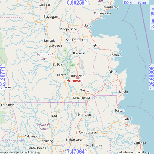
Bunawan GPS coordinates[2]
8° 10' 1.992" North, 125° 59' 26.988" East
| Map corner | latitude | longitude |
|---|---|---|
| Upper-left | 8.86259°, | 125.28771° |
| Center: | 8.16722°, | 125.99083° |
| Lower-right: | 7.47064°, | 126.69396° |
| Map W x H: | 154.8×154.8 km | = 96.2×96.2mi |
| max Lat: | 20.78733° ⇑81% North |
| Bunawan: | 8.16722° |
| min Lat: | ⇓19% South 4.65442° |
| min Long | Bunawan | max Long |
| 117.04868° | 125.99083° | 126.58417° |
| W 97.7%⇐ | ⇒2.3% E |
Elevation
Elevation of Bunawan is 25 m = 82 ft, and this is 62.9 m = 206 ft below average elevation for this country.
| Max E: |
2262 m = 7421 ft | 47.7% |
| Avg. | 87.9 m = 288 ft | |
| Bunawan | 25 m = 82 ft | |
Min E: |
-2 m = -7 ft | 52.3% |
See also: Philippines elevation on elevation.city.
Geographical zone
Bunawan is located in North Torrid zone (between Equator and Tropic of Cancer). Distance of Equator is 908.1 km =564.3 mi to South.| Distance of | km | miles | from Bunawan |
|---|---|---|---|
| North Pole | 9099 | 5653.9 | to North |
| Arctic Circle | 6493.1 | 4034.6 | to North |
| Tropic Cancer | 1697.8 | 1055 | to North |
| Equator | 908.1 | 564.3 | to South |


Nearby cities:
15 places around Bunawan: (largest is in red/bold)
• Basa
13.3 km =8.3 mi,  142°
142°
• Cuevas
20 km =12.4 mi,  145°
145°
• La Paz
24 km =14.9 mi,  298°
298°
• Lapinigan
28.2 km =17.5 mi,  358°
358°
• Libertad
7.7 km =4.8 mi, 149°
• Loreto
15.3 km =9.5 mi,  278°
278°
• Pasian
27.9 km =17.3 mi,  162°
162°
• Rosario
24.5 km =15.2 mi,  3°
3°
• Salvacion
23.8 km =14.8 mi, 141°
• Santa Josefa
20.1 km =12.5 mi,  167°
167°
• Santa Maria
24.1 km =15 mi,  128°
128°
• Santo Tomas
20.7 km =12.9 mi, 275°
• Sinubong
12.8 km =8 mi,  211°
211°
• Trento
15.7 km =9.8 mi, 149°
• Veruela
11.2 km =7 mi,  200°
200°
Sources, notices
• [Note1] Compared only with cities in Philippines existing in our database
• [Src1] Map data: © OpenStreetMap contributors (CC-BY-SA)
• [Src2] Other city data from geonames.org with taken over terms of usage.
• [Src3] Geographical zone / Annual Mean Temperature by Robert A. Rohde @ Wikipedia
