Pasian geodata
Pasian (Davao) is a populated place; located in Philippines in Asia/Manila (GMT+8) time zone. With population of 4,291 people, there are 1590 cities with bigger population in this country. Compared to other cities in Philippines, 83.3% of cities are located further ↑North; 98.2% of cities are located further ←West and 68.9% of cities have lower elevation than Pasian. Note1


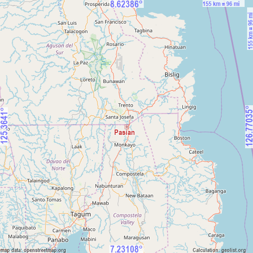
Pasian GPS coordinates[2]
7° 55' 41.016" North, 126° 4' 1.992" East
| Map corner | latitude | longitude |
|---|---|---|
| Upper-left | 8.62386°, | 125.3641° |
| Center: | 7.92806°, | 126.06722° |
| Lower-right: | 7.23108°, | 126.77035° |
| Map W x H: | 154.9×154.9 km | = 96.3×96.3mi |
| max Lat: | 20.78733° ⇑83.3% North |
| Pasian: | 7.92806° |
| min Lat: | ⇓16.7% South 4.65442° |
| min Long | Pasian | max Long |
| 117.04868° | 126.06722° | 126.58417° |
| W 98.2%⇐ | ⇒1.8% E |
Elevation
Elevation of Pasian is 50 m = 164 ft, and this is 37.9 m = 124 ft below average elevation for this country.
| Max E: |
2262 m = 7421 ft | 31.1% |
| Avg. | 87.9 m = 288 ft | |
| Pasian | 50 m = 164 ft | |
Min E: |
-2 m = -7 ft | 68.9% |
See also: Philippines elevation on elevation.city.
Geographical zone
Pasian is located in North Torrid zone (between Equator and Tropic of Cancer). Distance of Equator is 881.5 km =547.7 mi to South.| Distance of | km | miles | from Pasian |
|---|---|---|---|
| North Pole | 9125.5 | 5670.3 | to North |
| Arctic Circle | 6519.7 | 4051.2 | to North |
| Tropic Cancer | 1724.4 | 1071.5 | to North |
| Equator | 881.5 | 547.7 | to South |


Nearby cities:
15 places around Pasian: (largest is in red/bold)
• Babag
21.7 km =13.5 mi,  178°
178°
• Basa
16 km =9.9 mi,  358°
358°
• Baylo
8.2 km =5.1 mi,  188°
188°
• Cabinuangan
27.5 km =17.1 mi, 187°
• Cuevas
10.6 km =6.6 mi,  16°
16°
• Libertad
20.5 km =12.7 mi,  347°
347°
• Monkayo
12.6 km =7.8 mi, 186°
• Montevista
27.5 km =17.1 mi,  198°
198°
• Salvacion
10.2 km =6.3 mi,  38°
38°
• Santa Josefa
8.1 km =5 mi,  329°
329°
• Santa Maria
15.7 km =9.8 mi, 41°
• Sinubong
21.7 km =13.5 mi,  316°
316°
• Tapia
20.3 km =12.6 mi, 197°
• Trento
13.1 km =8.1 mi, 358°
• Veruela
20.3 km =12.6 mi, 322°
Sources, notices
• [Note1] Compared only with cities in Philippines existing in our database
• [Src1] Map data: © OpenStreetMap contributors (CC-BY-SA)
• [Src2] Other city data from geonames.org with taken over terms of usage.
• [Src3] Geographical zone / Annual Mean Temperature by Robert A. Rohde @ Wikipedia
