Trento geodata
Trento (Caraga) is a seat of a third-order administrative division; located in Philippines in Asia/Manila (GMT+8) time zone. With population of 15,916 people, there are 426 cities with bigger population in this country. Compared to other cities in Philippines, 82.2% of cities are located further ↑North; 98.2% of cities are located further ←West and 62.9% of cities have lower elevation than Trento. Note1


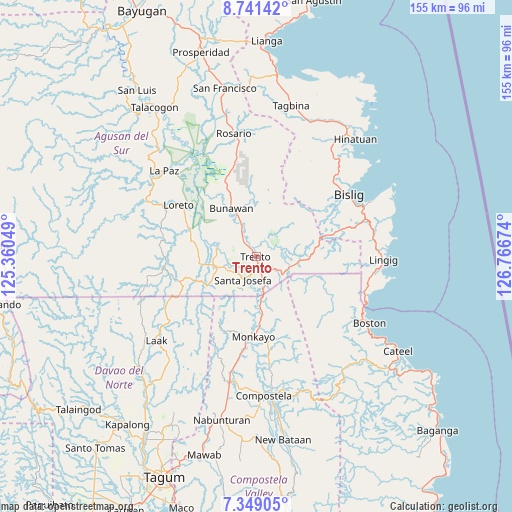
Trento GPS coordinates[2]
8° 2' 44.988" North, 126° 3' 48.996" East
| Map corner | latitude | longitude |
|---|---|---|
| Upper-left | 8.74142°, | 125.36049° |
| Center: | 8.04583°, | 126.06361° |
| Lower-right: | 7.34905°, | 126.76674° |
| Map W x H: | 154.8×154.8 km | = 96.2×96.2mi |
| max Lat: | 20.78733° ⇑82.2% North |
| Trento: | 8.04583° |
| min Lat: | ⇓17.8% South 4.65442° |
| min Long | Trento | max Long |
| 117.04868° | 126.06361° | 126.58417° |
| W 98.2%⇐ | ⇒1.8% E |
Elevation
Elevation of Trento is 38 m = 125 ft, and this is 49.9 m = 164 ft below average elevation for this country.
| Max E: |
2262 m = 7421 ft | 37.1% |
| Avg. | 87.9 m = 288 ft | |
| Trento | 38 m = 125 ft | |
Min E: |
-2 m = -7 ft | 62.9% |
See also: Philippines elevation on elevation.city.
Geographical zone
Trento is located in North Torrid zone (between Equator and Tropic of Cancer). Distance of Equator is 894.6 km =555.9 mi to South.| Distance of | km | miles | from Trento |
|---|---|---|---|
| North Pole | 9112.4 | 5662.2 | to North |
| Arctic Circle | 6506.6 | 4043 | to North |
| Tropic Cancer | 1711.3 | 1063.4 | to North |
| Equator | 894.6 | 555.9 | to South |


Nearby cities:
15 places around Trento: (largest is in red/bold)
• Basa
2.9 km =1.8 mi,  1°
1°
• Baylo
21.2 km =13.2 mi,  182°
182°
• Bunawan
15.7 km =9.8 mi,  329°
329°
• Cuevas
4.5 km =2.8 mi,  131°
131°
• Libertad
8 km =5 mi, 329°
• Loreto
28 km =17.4 mi,  304°
304°
• Monkayo
25.7 km =16 mi, 182°
• Pasian
13.1 km =8.1 mi, 178°
• Salvacion
8.5 km =5.3 mi, 127°
• Santa Josefa
7.1 km =4.4 mi,  211°
211°
• Santa Maria
11 km =6.8 mi,  97°
97°
• Santo Tomas
32.6 km =20.3 mi, 298°
• Sinubong
14.8 km =9.2 mi,  279°
279°
• Tapia
32.9 km =20.4 mi,  189°
189°
• Veruela
12.3 km =7.6 mi, 284°
Sources, notices
• [Note1] Compared only with cities in Philippines existing in our database
• [Src1] Map data: © OpenStreetMap contributors (CC-BY-SA)
• [Src2] Other city data from geonames.org with taken over terms of usage.
• [Src3] Geographical zone / Annual Mean Temperature by Robert A. Rohde @ Wikipedia
