Loreto geodata
Loreto (Caraga) is a populated place; located in Philippines in Asia/Manila (GMT+8) time zone. With population of 5,730 people, there are 1112 cities with bigger population in this country. Compared to other cities in Philippines, 80.9% of cities are located further ↑North; 96.9% of cities are located further ←West and 52.3% of cities have lower elevation than Loreto. Note1


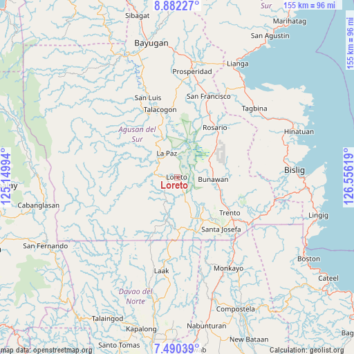
Loreto GPS coordinates[2]
8° 11' 12.984" North, 125° 51' 11.016" East
| Map corner | latitude | longitude |
|---|---|---|
| Upper-left | 8.88227°, | 125.14994° |
| Center: | 8.18694°, | 125.85306° |
| Lower-right: | 7.49039°, | 126.55619° |
| Map W x H: | 154.8×154.8 km | = 96.2×96.2mi |
| max Lat: | 20.78733° ⇑80.9% North |
| Loreto: | 8.18694° |
| min Lat: | ⇓19.1% South 4.65442° |
| min Long | Loreto | max Long |
| 117.04868° | 125.85306° | 126.58417° |
| W 96.9%⇐ | ⇒3.1% E |
Elevation
Elevation of Loreto is 25 m = 82 ft, and this is 62.9 m = 206 ft below average elevation for this country.
| Max E: |
2262 m = 7421 ft | 47.7% |
| Avg. | 87.9 m = 288 ft | |
| Loreto | 25 m = 82 ft | |
Min E: |
-2 m = -7 ft | 52.3% |
See also: Philippines elevation on elevation.city.
Geographical zone
Loreto is located in North Torrid zone (between Equator and Tropic of Cancer). Distance of Equator is 910.3 km =565.6 mi to South.| Distance of | km | miles | from Loreto |
|---|---|---|---|
| North Pole | 9096.8 | 5652.5 | to North |
| Arctic Circle | 6490.9 | 4033.3 | to North |
| Tropic Cancer | 1695.6 | 1053.6 | to North |
| Equator | 910.3 | 565.6 | to South |


Nearby cities:
15 places around Loreto: (largest is in red/bold)
• Basa
26.5 km =16.5 mi,  118°
118°
• Binucayan
16.6 km =10.3 mi,  295°
295°
• Bunawan
15.3 km =9.5 mi,  98°
98°
• Causwagan
29 km =18 mi,  357°
357°
• Cuevas
32.4 km =20.1 mi,  125°
125°
• La Paz
11 km =6.8 mi,  327°
327°
• Lapinigan
29.6 km =18.4 mi,  28°
28°
• Libertad
21 km =13 mi,  114°
114°
• Rosario
27.7 km =17.2 mi,  36°
36°
• Santa Josefa
29.2 km =18.1 mi,  138°
138°
• Santo Tomas
5.4 km =3.4 mi,  268°
268°
• Sinubong
15.7 km =9.8 mi,  147°
147°
• Talacogon
30.9 km =19.2 mi,  345°
345°
• Trento
28 km =17.4 mi, 124°
• Veruela
17 km =10.6 mi, 138°
Sources, notices
• [Note1] Compared only with cities in Philippines existing in our database
• [Src1] Map data: © OpenStreetMap contributors (CC-BY-SA)
• [Src2] Other city data from geonames.org with taken over terms of usage.
• [Src3] Geographical zone / Annual Mean Temperature by Robert A. Rohde @ Wikipedia
