Rotonda geodata
Rotonda (Soccsksargen) is a populated place; located in Philippines in Asia/Manila (GMT+8) time zone. With population of 2,712 people, there are 2929 cities with bigger population in this country. Compared to other cities in Philippines, 95.7% of cities are located further ↑North; 86% of cities are located further ←West and 76.6% of cities have lower elevation than Rotonda. Note1
Administrative division(s):
- Level 1: Soccsksargen
- Level 2: Province of South Cotabato
- Level 3: City of Koronadal


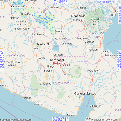
Rotonda GPS coordinates[2]
6° 29' 30.444" North, 124° 53' 10.176" East
| Map corner | latitude | longitude |
|---|---|---|
| Upper-left | 7.1899°, | 124.18304° |
| Center: | 6.49179°, | 124.88616° |
| Lower-right: | 5.79271°, | 125.58929° |
| Map W x H: | 155.4×155.4 km | = 96.6×96.6mi |
| max Lat: | 20.78733° ⇑95.7% North |
| Rotonda: | 6.49179° |
| min Lat: | ⇓4.3% South 4.65442° |
| min Long | Rotonda | max Long |
| 117.04868° | 124.88616° | 126.58417° |
| W 86%⇐ | ⇒14% E |
Elevation
Elevation of Rotonda is 74 m = 243 ft, and this is 13.9 m = 46 ft below average elevation for this country.
| Max E: |
2262 m = 7421 ft | 23.4% |
| Avg. | 87.9 m = 288 ft | |
| Rotonda | 74 m = 243 ft | |
Min E: |
-2 m = -7 ft | 76.6% |
See also: Philippines elevation on elevation.city.
Geographical zone
Rotonda is located in North Torrid zone (between Equator and Tropic of Cancer). Distance of Equator is 721.8 km =448.5 mi to South.| Distance of | km | miles | from Rotonda |
|---|---|---|---|
| North Pole | 9285.2 | 5769.6 | to North |
| Arctic Circle | 6679.4 | 4150.4 | to North |
| Tropic Cancer | 1884.1 | 1170.7 | to North |
| Equator | 721.8 | 448.5 | to South |


Nearby cities:
15 places around Rotonda: (largest is in red/bold)
• Blingkong
10.7 km =6.6 mi,  1°
1°
• Carpenter Hill
5.3 km =3.3 mi,  185°
185°
• Kipalbig
10.1 km =6.3 mi,  153°
153°
• Koronadal
4.5 km =2.8 mi,  286°
286°
• Libas
11.9 km =7.4 mi, 285°
• Liberty
11.4 km =7.1 mi,  110°
110°
• Linan
12 km =7.5 mi,  123°
123°
• Mabini
2.9 km =1.8 mi,  57°
57°
• Maindang
11.7 km =7.3 mi,  338°
338°
• Maltana
9.5 km =5.9 mi,  143°
143°
• New Iloilo
12.4 km =7.7 mi,  300°
300°
• Palian
13.3 km =8.3 mi,  168°
168°
• Paraiso
8.6 km =5.3 mi,  258°
258°
• San Vicente
12.5 km =7.8 mi,  250°
250°
• Tamnag
9.1 km =5.7 mi,  355°
355°
Sources, notices
• [Note1] Compared only with cities in Philippines existing in our database
• [Src1] Map data: © OpenStreetMap contributors (CC-BY-SA)
• [Src2] Other city data from geonames.org with taken over terms of usage.
• [Src3] Geographical zone / Annual Mean Temperature by Robert A. Rohde @ Wikipedia
