Taclobo geodata
Taclobo (Mimaropa) is a populated place; located in Philippines in Asia/Manila (GMT+8) time zone. With population of 4,782 people, there are 1383 cities with bigger population in this country. Compared to other cities in Philippines, 53.4% of cities are located further ↓South; 53.2% of cities are located further →East and 73.2% of cities have higher elevation than Taclobo. Note1


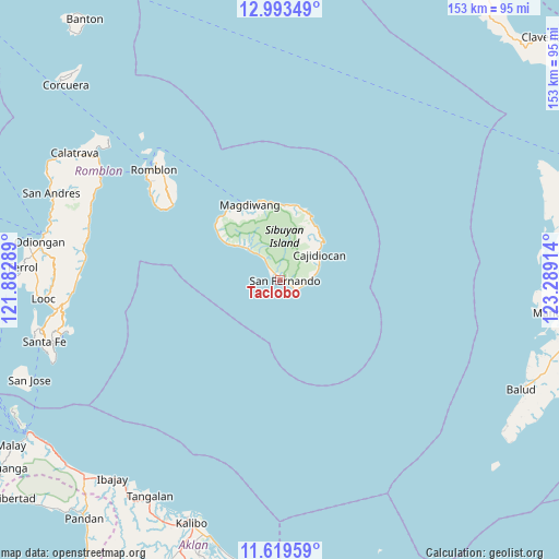
Taclobo GPS coordinates[2]
12° 18' 26.784" North, 122° 35' 9.636" East
| Map corner | latitude | longitude |
|---|---|---|
| Upper-left | 12.99349°, | 121.88289° |
| Center: | 12.30744°, | 122.58601° |
| Lower-right: | 11.61959°, | 123.28914° |
| Map W x H: | 152.8×152.8 km | = 94.9×94.9mi |
| max Lat: | 20.78733° ⇑46.6% North |
| Taclobo: | 12.30744° |
| min Lat: | ⇓53.4% South 4.65442° |
| min Long | Taclobo | max Long |
| 117.04868° | 122.58601° | 126.58417° |
| W 46.8%⇐ | ⇒53.2% E |
Elevation
Elevation of Taclobo is 11 m = 36 ft, and this is 76.9 m = 252 ft below average elevation for this country.
| Max E: |
2262 m = 7421 ft | 73.2% |
| Avg. | 87.9 m = 288 ft | |
| Taclobo | 11 m = 36 ft | |
Min E: |
-2 m = -7 ft | 26.8% |
See also: Philippines elevation on elevation.city.
Geographical zone
Taclobo is located in North Torrid zone (between Equator and Tropic of Cancer). Distance of this Northern Tropic circle is 1237.5 km =768.9 mi to North.| Distance of | km | miles | from Taclobo |
|---|---|---|---|
| North Pole | 8638.6 | 5367.8 | to North |
| Arctic Circle | 6032.7 | 3748.5 | to North |
| Tropic Cancer | 1237.5 | 768.9 | to North |
| Equator | 1368.5 | 850.3 | to South |


Nearby cities:
15 places around Taclobo: (largest is in red/bold)
• Alad
50.3 km =31.3 mi,  313°
313°
• Alcantara
58 km =36 mi,  264°
264°
• Cajidiocan
12.3 km =7.6 mi,  57°
57°
• Cajimos
46.5 km =28.9 mi, 313°
• Concepcion
54.4 km =33.8 mi,  280°
280°
• Dobdoban
59.3 km =36.8 mi,  300°
300°
• España
12.7 km =7.9 mi, 312°
• Magdiwang
21.1 km =13.1 mi,  338°
338°
• Pato-o
58.1 km =36.1 mi, 283°
• Romblon
45.4 km =28.2 mi, 311°
• San Agustin
57.3 km =35.6 mi, 300°
• San Fernando
1.6 km =1 mi,  105°
105°
• Sogod
11.4 km =7.1 mi,  47°
47°
• Tampayan
21.5 km =13.4 mi, 344°
• Tugdan
54.4 km =33.8 mi,  270°
270°
Sources, notices
• [Note1] Compared only with cities in Philippines existing in our database
• [Src1] Map data: © OpenStreetMap contributors (CC-BY-SA)
• [Src2] Other city data from geonames.org with taken over terms of usage.
• [Src3] Geographical zone / Annual Mean Temperature by Robert A. Rohde @ Wikipedia
