Sogod geodata
Sogod (Mimaropa) is a populated place; located in Philippines in Asia/Manila (GMT+8) time zone. With population of 2,221 people, there are 3846 cities with bigger population in this country. Compared to other cities in Philippines, 53.9% of cities are located further ↓South; 52% of cities are located further →East and 88.4% of cities have lower elevation than Sogod. Note1


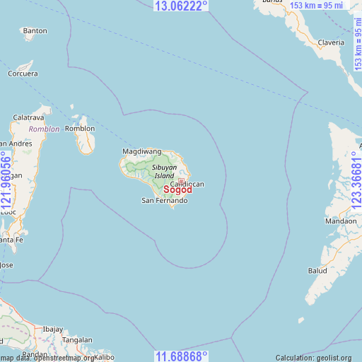
Sogod GPS coordinates[2]
12° 22' 34.86" North, 122° 39' 49.248" East
| Map corner | latitude | longitude |
|---|---|---|
| Upper-left | 13.06222°, | 121.96056° |
| Center: | 12.37635°, | 122.66368° |
| Lower-right: | 11.68868°, | 123.36681° |
| Map W x H: | 152.7×152.7 km | = 94.9×94.9mi |
| max Lat: | 20.78733° ⇑46.1% North |
| Sogod: | 12.37635° |
| min Lat: | ⇓53.9% South 4.65442° |
| min Long | Sogod | max Long |
| 117.04868° | 122.66368° | 126.58417° |
| W 48%⇐ | ⇒52% E |
Elevation
Elevation of Sogod is 190 m = 623 ft, and this is 102.1 m = 335 ft above average elevation for this country.
| Max E: |
2262 m = 7421 ft | 11.6% |
| Sogod | 190 m 623 ft | |
| Avg. | 87.9 m = 288 ft | |
Min E: |
-2 m = -7 ft | 88.4% |
See also: Philippines elevation on elevation.city.
Geographical zone
Sogod is located in North Torrid zone (between Equator and Tropic of Cancer). Distance of this Northern Tropic circle is 1229.8 km =764.2 mi to North.| Distance of | km | miles | from Sogod |
|---|---|---|---|
| North Pole | 8630.9 | 5363 | to North |
| Arctic Circle | 6025.1 | 3743.8 | to North |
| Tropic Cancer | 1229.8 | 764.2 | to North |
| Equator | 1376.1 | 855.1 | to South |


Nearby cities:
15 places around Sogod: (largest is in red/bold)
• Alad
52.5 km =32.6 mi,  300°
300°
• Cajidiocan
2.2 km =1.4 mi,  118°
118°
• Cajimos
48.6 km =30.2 mi, 299°
• Carmen
64.7 km =40.2 mi,  294°
294°
• Concepcion
62 km =38.5 mi,  272°
272°
• Dobdoban
63.6 km =39.5 mi, 290°
• España
17.9 km =11.1 mi, 272°
• Magdiwang
20.1 km =12.5 mi,  306°
306°
• Romblon
48 km =29.8 mi, 297°
• San Agustin
61.6 km =38.3 mi, 290°
• San Fernando
10.6 km =6.6 mi,  220°
220°
• Taclobo
11.4 km =7.1 mi,  227°
227°
• Tampayan
19.3 km =12 mi, 312°
• Tugdan
63.2 km =39.3 mi,  263°
263°
• Tumalaytay
62.7 km =39 mi,  100°
100°
Sources, notices
• [Note1] Compared only with cities in Philippines existing in our database
• [Src1] Map data: © OpenStreetMap contributors (CC-BY-SA)
• [Src2] Other city data from geonames.org with taken over terms of usage.
• [Src3] Geographical zone / Annual Mean Temperature by Robert A. Rohde @ Wikipedia
