Unidos geodata
Unidos (Northern Mindanao) is a populated place; located in Philippines in Asia/Manila (GMT+8) time zone. With population of 2,111 people, there are 4056 cities with bigger population in this country. Compared to other cities in Philippines, 77.7% of cities are located further ↑North; 65% of cities are located further ←West and 62.2% of cities have lower elevation than Unidos. Note1
Administrative division(s):
- Level 1: Northern Mindanao
- Level 2: Province of Misamis Occidental
- Level 3: Plaridel


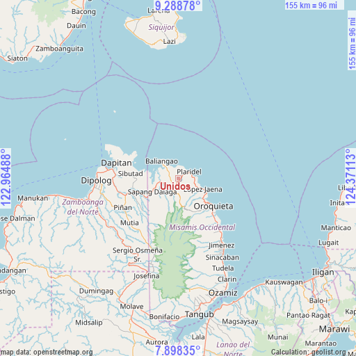
Unidos GPS coordinates[2]
8° 35' 39.12" North, 123° 40' 4.8" East
| Map corner | latitude | longitude |
|---|---|---|
| Upper-left | 9.28878°, | 122.96488° |
| Center: | 8.5942°, | 123.668° |
| Lower-right: | 7.89835°, | 124.37113° |
| Map W x H: | 154.6×154.6 km | = 96.1×96.1mi |
| max Lat: | 20.78733° ⇑77.7% North |
| Unidos: | 8.5942° |
| min Lat: | ⇓22.3% South 4.65442° |
| min Long | Unidos | max Long |
| 117.04868° | 123.668° | 126.58417° |
| W 65%⇐ | ⇒35% E |
Elevation
Elevation of Unidos is 37 m = 121 ft, and this is 50.9 m = 167 ft below average elevation for this country.
| Max E: |
2262 m = 7421 ft | 37.8% |
| Avg. | 87.9 m = 288 ft | |
| Unidos | 37 m = 121 ft | |
Min E: |
-2 m = -7 ft | 62.2% |
See also: Philippines elevation on elevation.city.
Geographical zone
Unidos is located in North Torrid zone (between Equator and Tropic of Cancer). Distance of Equator is 955.6 km =593.8 mi to South.| Distance of | km | miles | from Unidos |
|---|---|---|---|
| North Pole | 9051.5 | 5624.3 | to North |
| Arctic Circle | 6445.6 | 4005.1 | to North |
| Tropic Cancer | 1650.3 | 1025.4 | to North |
| Equator | 955.6 | 593.8 | to South |


Nearby cities:
15 places around Unidos: (largest is in red/bold)
• Barcelona
24.2 km =15 mi,  252°
252°
• Bato
2.7 km =1.7 mi,  290°
290°
• Calamba
4.8 km =3 mi,  215°
215°
• Dapitan
27.8 km =17.3 mi,  284°
284°
• Ilaya
26.6 km =16.5 mi,  258°
258°
• Jimenez
34.2 km =21.3 mi,  146°
146°
• Langcangan
16 km =9.9 mi,  142°
142°
• Lingasan
31.4 km =19.5 mi, 249°
• Lopez Jaena
11.3 km =7 mi,  114°
114°
• Oroquieta
19.3 km =12 mi,  128°
128°
• Pines
22 km =13.7 mi, 135°
• Plaridel
5.5 km =3.4 mi,  56°
56°
• Polanco
34.4 km =21.4 mi, 258°
• Sapang Dalaga
13.1 km =8.1 mi,  242°
242°
• Sibutao
20 km =12.4 mi,  269°
269°
Sources, notices
• [Note1] Compared only with cities in Philippines existing in our database
• [Src1] Map data: © OpenStreetMap contributors (CC-BY-SA)
• [Src2] Other city data from geonames.org with taken over terms of usage.
• [Src3] Geographical zone / Annual Mean Temperature by Robert A. Rohde @ Wikipedia
