Bato geodata
Bato (Northern Mindanao) is a populated place; located in Philippines in Asia/Manila (GMT+8) time zone. With population of 2,789 people, there are 2805 cities with bigger population in this country. Compared to other cities in Philippines, 77.6% of cities are located further ↑North; 64.7% of cities are located further ←West and 63.6% of cities have lower elevation than Bato. Note1
Administrative division(s):
- Level 1: Northern Mindanao
- Level 2: Province of Misamis Occidental
- Level 3: Baliangao


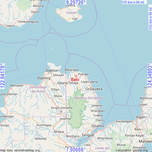
Bato GPS coordinates[2]
8° 36' 9.72" North, 123° 38' 41.64" East
| Map corner | latitude | longitude |
|---|---|---|
| Upper-left | 9.29726°, | 122.94178° |
| Center: | 8.6027°, | 123.6449° |
| Lower-right: | 7.90686°, | 124.34803° |
| Map W x H: | 154.6×154.6 km | = 96.1×96.1mi |
| max Lat: | 20.78733° ⇑77.6% North |
| Bato: | 8.6027° |
| min Lat: | ⇓22.4% South 4.65442° |
| min Long | Bato | max Long |
| 117.04868° | 123.6449° | 126.58417° |
| W 64.7%⇐ | ⇒35.3% E |
Elevation
Elevation of Bato is 39 m = 128 ft, and this is 48.9 m = 160 ft below average elevation for this country.
| Max E: |
2262 m = 7421 ft | 36.4% |
| Avg. | 87.9 m = 288 ft | |
| Bato | 39 m = 128 ft | |
Min E: |
-2 m = -7 ft | 63.6% |
See also: Philippines elevation on elevation.city.
Geographical zone
Bato is located in North Torrid zone (between Equator and Tropic of Cancer). Distance of Equator is 956.5 km =594.3 mi to South.| Distance of | km | miles | from Bato |
|---|---|---|---|
| North Pole | 9050.5 | 5623.7 | to North |
| Arctic Circle | 6444.6 | 4004.5 | to North |
| Tropic Cancer | 1649.4 | 1024.9 | to North |
| Equator | 956.5 | 594.3 | to South |


Nearby cities:
15 places around Bato: (largest is in red/bold)
• Barcelona
22.1 km =13.7 mi,  247°
247°
• Calamba
4.9 km =3 mi,  183°
183°
• Dapitan
25.1 km =15.6 mi,  283°
283°
• Dipolog
34.3 km =21.3 mi,  263°
263°
• Ilaya
24.4 km =15.2 mi, 254°
• Langcangan
18.3 km =11.4 mi,  138°
138°
• Lingasan
29.4 km =18.3 mi, 246°
• Lopez Jaena
14 km =8.7 mi,  113°
113°
• Oroquieta
21.9 km =13.6 mi,  126°
126°
• Pines
24.5 km =15.2 mi, 133°
• Plaridel
7.5 km =4.7 mi,  73°
73°
• Polanco
32.1 km =19.9 mi, 256°
• Sapang Dalaga
11.4 km =7.1 mi,  232°
232°
• Sibutao
17.5 km =10.9 mi,  265°
265°
• Unidos
2.7 km =1.7 mi, 110°
Sources, notices
• [Note1] Compared only with cities in Philippines existing in our database
• [Src1] Map data: © OpenStreetMap contributors (CC-BY-SA)
• [Src2] Other city data from geonames.org with taken over terms of usage.
• [Src3] Geographical zone / Annual Mean Temperature by Robert A. Rohde @ Wikipedia
