Calamba geodata
Calamba (Northern Mindanao) is a populated place; located in Philippines in Asia/Manila (GMT+8) time zone. With population of 6,738 people, there are 931 cities with bigger population in this country. Compared to other cities in Philippines, 78% of cities are located further ↑North; 64.6% of cities are located further ←West and 82.9% of cities have lower elevation than Calamba. Note1
Administrative division(s):
- Level 1: Northern Mindanao
- Level 2: Province of Misamis Occidental
- Level 3: Calamba


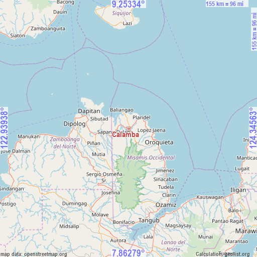
Calamba GPS coordinates[2]
8° 33' 31.32" North, 123° 38' 33" East
| Map corner | latitude | longitude |
|---|---|---|
| Upper-left | 9.25334°, | 122.93938° |
| Center: | 8.5587°, | 123.6425° |
| Lower-right: | 7.86279°, | 124.34563° |
| Map W x H: | 154.6×154.6 km | = 96.1×96.1mi |
| max Lat: | 20.78733° ⇑78% North |
| Calamba: | 8.5587° |
| min Lat: | ⇓22% South 4.65442° |
| min Long | Calamba | max Long |
| 117.04868° | 123.6425° | 126.58417° |
| W 64.6%⇐ | ⇒35.4% E |
Elevation
Elevation of Calamba is 115 m = 377 ft, and this is 27.1 m = 89 ft above average elevation for this country.
| Max E: |
2262 m = 7421 ft | 17.1% |
| Calamba | 115 m 377 ft | |
| Avg. | 87.9 m = 288 ft | |
Min E: |
-2 m = -7 ft | 82.9% |
See also: Philippines elevation on elevation.city.
Geographical zone
Calamba is located in North Torrid zone (between Equator and Tropic of Cancer). Distance of Equator is 951.6 km =591.3 mi to South.| Distance of | km | miles | from Calamba |
|---|---|---|---|
| North Pole | 9055.4 | 5626.8 | to North |
| Arctic Circle | 6449.5 | 4007.5 | to North |
| Tropic Cancer | 1654.3 | 1027.9 | to North |
| Equator | 951.6 | 591.3 | to South |


Nearby cities:
15 places around Calamba: (largest is in red/bold)
• Barcelona
20.5 km =12.7 mi,  260°
260°
• Bato
4.9 km =3 mi,  3°
3°
• Dapitan
26.5 km =16.5 mi,  294°
294°
• Ilaya
23.3 km =14.5 mi,  266°
266°
• Jimenez
32.8 km =20.4 mi,  138°
138°
• Langcangan
15.3 km =9.5 mi,  125°
125°
• Lingasan
27.6 km =17.1 mi, 255°
• Lopez Jaena
13.1 km =8.1 mi,  92°
92°
• Oroquieta
19.6 km =12.2 mi,  114°
114°
• Pines
21.7 km =13.5 mi,  123°
123°
• Plaridel
10.2 km =6.3 mi,  46°
46°
• Polanco
31 km =19.3 mi, 264°
• Sapang Dalaga
9.1 km =5.7 mi, 256°
• Sibutao
17.6 km =10.9 mi,  281°
281°
• Unidos
4.8 km =3 mi,  35°
35°
Sources, notices
• [Note1] Compared only with cities in Philippines existing in our database
• [Src1] Map data: © OpenStreetMap contributors (CC-BY-SA)
• [Src2] Other city data from geonames.org with taken over terms of usage.
• [Src3] Geographical zone / Annual Mean Temperature by Robert A. Rohde @ Wikipedia
