Santa Monica geodata
Santa Monica (Caraga) is a seat of a third-order administrative division; located in Philippines in Asia/Manila (GMT+8) time zone. With population of 2,284 people, there are 3714 cities with bigger population in this country. Compared to other cities in Philippines, 68.1% of cities are located further ↑North; 98% of cities are located further ←West and 65.1% of cities have higher elevation than Santa Monica. Note1
Administrative division(s):
- Level 1: Caraga
- Level 2: Province of Surigao del Norte
- Level 3: Santa Monica (Sapao)


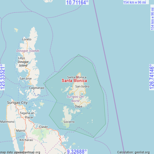
Santa Monica GPS coordinates[2]
10° 1' 12" North, 126° 2' 17.988" East
| Map corner | latitude | longitude |
|---|---|---|
| Upper-left | 10.71164°, | 125.33521° |
| Center: | 10.02°, | 126.03833° |
| Lower-right: | 9.32688°, | 126.74146° |
| Map W x H: | 154×154 km | = 95.7×95.7mi |
| max Lat: | 20.78733° ⇑68.1% North |
| Santa Monica: | 10.02° |
| min Lat: | ⇓31.9% South 4.65442° |
| min Long | Santa Monica | max Long |
| 117.04868° | 126.03833° | 126.58417° |
| W 98%⇐ | ⇒2% E |
Elevation
Elevation of Santa Monica is 14 m = 46 ft, and this is 73.9 m = 242 ft below average elevation for this country.
| Max E: |
2262 m = 7421 ft | 65.1% |
| Avg. | 87.9 m = 288 ft | |
| Santa Monica | 14 m = 46 ft | |
Min E: |
-2 m = -7 ft | 34.9% |
See also: Philippines elevation on elevation.city.
Geographical zone
Santa Monica is located in North Torrid zone (between Equator and Tropic of Cancer). Distance of Equator is 1114.1 km =692.3 mi to South.| Distance of | km | miles | from Santa Monica |
|---|---|---|---|
| North Pole | 8892.9 | 5525.8 | to North |
| Arctic Circle | 6287.1 | 3906.6 | to North |
| Tropic Cancer | 1491.8 | 927 | to North |
| Equator | 1114.1 | 692.3 | to South |


Nearby cities:
15 places around Santa Monica: (largest is in red/bold)
• Basilisa
59 km =36.7 mi,  267°
267°
• Cagdianao
41.9 km =26 mi,  254°
254°
• Dapa
29 km =18 mi,  176°
176°
• Del Carmen, Surigao del Norte
18.3 km =11.4 mi,  204°
204°
• Dinagat
49.2 km =30.6 mi,  261°
261°
• General Luna
29.4 km =18.3 mi,  153°
153°
• Libas
16.3 km =10.1 mi, 201°
• Libjo
58.5 km =36.4 mi,  289°
289°
• Pilar
18.5 km =11.5 mi,  158°
158°
• San Benito
7.7 km =4.8 mi,  206°
206°
• San Isidro
10.8 km =6.7 mi, 149°
• San Jose
54.4 km =33.8 mi, 289°
• Socorro
45 km =28 mi,  190°
190°
• Talisay
51.4 km =31.9 mi,  244°
244°
• Union
30.3 km =18.8 mi, 164°
Sources, notices
• [Note1] Compared only with cities in Philippines existing in our database
• [Src1] Map data: © OpenStreetMap contributors (CC-BY-SA)
• [Src2] Other city data from geonames.org with taken over terms of usage.
• [Src3] Geographical zone / Annual Mean Temperature by Robert A. Rohde @ Wikipedia
