Union geodata
Union (Caraga) is a populated place; located in Philippines in Asia/Manila (GMT+8) time zone. With population of 2,368 people, there are 3521 cities with bigger population in this country. Compared to other cities in Philippines, 70.9% of cities are located further ↑North; 98.7% of cities are located further ←West and 76.6% of cities have higher elevation than Union. Note1


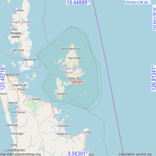
Union GPS coordinates[2]
9° 45' 24.012" North, 126° 6' 37.008" East
| Map corner | latitude | longitude |
|---|---|---|
| Upper-left | 10.44889°, | 125.40716° |
| Center: | 9.75667°, | 126.11028° |
| Lower-right: | 9.06301°, | 126.81341° |
| Map W x H: | 154.1×154.1 km | = 95.8×95.8mi |
| max Lat: | 20.78733° ⇑70.9% North |
| Union: | 9.75667° |
| min Lat: | ⇓29.1% South 4.65442° |
| min Long | Union | max Long |
| 117.04868° | 126.11028° | 126.58417° |
| W 98.7%⇐ | ⇒1.3% E |
Elevation
Elevation of Union is 10 m = 33 ft, and this is 77.9 m = 256 ft below average elevation for this country.
| Max E: |
2262 m = 7421 ft | 76.6% |
| Avg. | 87.9 m = 288 ft | |
| Union | 10 m = 33 ft | |
Min E: |
-2 m = -7 ft | 23.4% |
See also: Philippines elevation on elevation.city.
Geographical zone
Union is located in North Torrid zone (between Equator and Tropic of Cancer). Distance of Equator is 1084.8 km =674.1 mi to South.| Distance of | km | miles | from Union |
|---|---|---|---|
| North Pole | 8922.2 | 5544 | to North |
| Arctic Circle | 6316.3 | 3924.8 | to North |
| Tropic Cancer | 1521.1 | 945.2 | to North |
| Equator | 1084.8 | 674.1 | to South |


Nearby cities:
15 places around Union: (largest is in red/bold)
• Adlay
45.1 km =28 mi,  211°
211°
• Cantilan
49.2 km =30.6 mi,  197°
197°
• Carrascal
46.5 km =28.9 mi, 202°
• Claver
46.1 km =28.6 mi,  243°
243°
• Dapa
6.3 km =3.9 mi,  272°
272°
• Del Carmen, Surigao del Norte
19.9 km =12.4 mi,  309°
309°
• General Luna
6.1 km =3.8 mi,  60°
60°
• Gigaquit
48.7 km =30.3 mi,  248°
248°
• Libas
19.8 km =12.3 mi,  315°
315°
• Panikian
51.3 km =31.9 mi, 202°
• Pilar
12.1 km =7.5 mi,  354°
354°
• San Benito
25.1 km =15.6 mi,  333°
333°
• San Isidro
20.2 km =12.6 mi, 353°
• Santa Monica
30.3 km =18.8 mi,  344°
344°
• Socorro
21.8 km =13.5 mi,  226°
226°
Sources, notices
• [Note1] Compared only with cities in Philippines existing in our database
• [Src1] Map data: © OpenStreetMap contributors (CC-BY-SA)
• [Src2] Other city data from geonames.org with taken over terms of usage.
• [Src3] Geographical zone / Annual Mean Temperature by Robert A. Rohde @ Wikipedia
