General Luna geodata
General Luna (Caraga) is a seat of a third-order administrative division; located in Philippines in Asia/Manila (GMT+8) time zone. In our database, there are 4166 cities with bigger population. Compared to other cities in Philippines, 70.6% of cities are located further ↑North; 98.8% of cities are located further ←West and 70.2% of cities have higher elevation than General Luna. Note1
Administrative division(s):
- Level 1: Caraga
- Level 2: Province of Surigao del Norte
- Level 3: General Luna


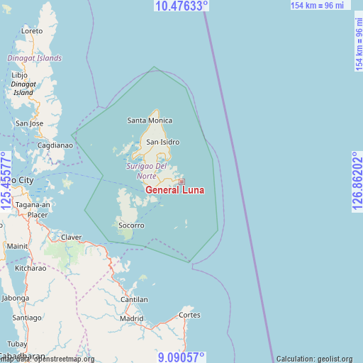
General Luna GPS coordinates[2]
9° 47' 3.012" North, 126° 9' 32.004" East
| Map corner | latitude | longitude |
|---|---|---|
| Upper-left | 10.47633°, | 125.45577° |
| Center: | 9.78417°, | 126.15889° |
| Lower-right: | 9.09057°, | 126.86202° |
| Map W x H: | 154.1×154.1 km | = 95.8×95.8mi |
| max Lat: | 20.78733° ⇑70.6% North |
| General Luna: | 9.78417° |
| min Lat: | ⇓29.4% South 4.65442° |
| min Long | General Luna | max Long |
| 117.04868° | 126.15889° | 126.58417° |
| W 98.8%⇐ | ⇒1.2% E |
Elevation
Elevation of General Luna is 12 m = 39 ft, and this is 75.9 m = 249 ft below average elevation for this country.
| Max E: |
2262 m = 7421 ft | 70.2% |
| Avg. | 87.9 m = 288 ft | |
| General Luna | 12 m = 39 ft | |
Min E: |
-2 m = -7 ft | 29.8% |
See also: Philippines elevation on elevation.city.
Geographical zone
General Luna is located in North Torrid zone (between Equator and Tropic of Cancer). Distance of Equator is 1087.9 km =676 mi to South.| Distance of | km | miles | from General Luna |
|---|---|---|---|
| North Pole | 8919.2 | 5542.1 | to North |
| Arctic Circle | 6313.3 | 3922.9 | to North |
| Tropic Cancer | 1518 | 943.2 | to North |
| Equator | 1087.9 | 676 | to South |


Nearby cities:
15 places around General Luna: (largest is in red/bold)
• Adlay
50.5 km =31.4 mi,  214°
214°
• Cagdianao
55.8 km =34.7 mi,  285°
285°
• Cantilan
53.9 km =33.5 mi,  201°
201°
• Carrascal
51.4 km =31.9 mi, 206°
• Claver
52.3 km =32.5 mi,  243°
243°
• Dapa
11.9 km =7.4 mi,  256°
256°
• Del Carmen, Surigao del Norte
22.8 km =14.2 mi, 294°
• Gigaquit
54.8 km =34.1 mi,  247°
247°
• Libas
22.2 km =13.8 mi,  299°
299°
• Pilar
11.1 km =6.9 mi,  324°
324°
• San Benito
25.5 km =15.8 mi, 319°
• San Isidro
18.6 km =11.6 mi,  335°
335°
• Santa Monica
29.4 km =18.3 mi,  333°
333°
• Socorro
27.8 km =17.3 mi,  229°
229°
• Union
6.1 km =3.8 mi, 240°
Sources, notices
• [Note1] Compared only with cities in Philippines existing in our database
• [Src1] Map data: © OpenStreetMap contributors (CC-BY-SA)
• [Src2] Other city data from geonames.org with taken over terms of usage.
• [Src3] Geographical zone / Annual Mean Temperature by Robert A. Rohde @ Wikipedia
